
-
Welcome to TalkWeather! We see you lurking around TalkWeather! Take the extra step and join us today to view attachments, see less ads and maybe even join the discussion. CLICK TO JOIN TALKWEATHER -
 April 2024 Weather Video of the Month Post your nominations now!
You are using an out of date browser. It may not display this or other websites correctly.
You should upgrade or use an alternative browser.
You should upgrade or use an alternative browser.
Archive Severe Potential 4/3-4/4
- Thread starter rolltide_130
- Start date

rolltide_130
Member
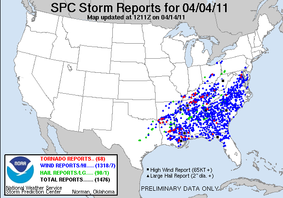
Looking at that large MDT driven by wind, you gotta wonder if we’re about to see another April 4-5, 2011.
That day had a perfect little Madison county sized bubble where no significant severe weather occurred yet everywhere around us got lambasted. I have an exam tomorrow so I wouldn't exactly complain if some wind gusts conveniently knocked out power to UAH until around 10 or so tomorrow morning.
That's a pretty large moderate outlook, and given models underdoing of several important severe parameters I think it's a pretty good call. Looks like this April is shaping up to be more active than the previous few years.
tennessee storm chaser
Member
I’m taking off work shortly. Going set up around nwtenn vicinity . Bout 30 minutes drive for me. Hope to catch some nice discrete cells early ....


CheeselandSkies
Member
That's a pretty large moderate outlook, and given models underdoing of several important severe parameters I think it's a pretty good call. Looks like this April is shaping up to be more active than the previous few years.
It's certainly getting interesting sooner than I'd anticipated given the pattern. I'll armchair chase while my apartment heater is going full blast. My side mirrors were iced over when I left work today.
Probs on that new watch for the western/southern portion of the risk area are impressive. Just shy of PDS territory.
HazardousWx
Member
There has been a fair amount of sunshine up here in North AL. However, I'm noticing the dewpoint still around 58F in Huntsville.
There has been a fair amount of sunshine up here in North AL. However, I'm noticing the dewpoint still around 58F in Huntsville.
Its the same here in the Shoals. Temp at 80 but dewpoint 56. The wind is crazy though.
The Nino
Member
There has been a fair amount of sunshine up here in North AL. However, I'm noticing the dewpoint still around 58F in Huntsville.
Speaking of Huntsville, what is this system looking like over here? I have been out of pocket for this system.
SilentShadow87
Member
Just out of curiosity what app are you using? It looks much better than the one I'm using right now.View attachment 582 Severe storms firing just north of my location before the dryline even gets here. I'd watch out east of here folks.
HazardousWx
Member
As an aside, an outdoor warning siren was just put in up on Keel. Depending on where you live up there will determine if you will hear it or not due to all the trees.Speaking of Huntsville, what is this system looking like over here? I have been out of pocket for this system.
Just out of curiosity what app are you using? It looks much better than the one I'm using right now.
That looks like Radarscope for Mac OS.
The Nino
Member
As an aside, an outdoor warning siren was just put in up on Keel. Depending on where you live up there will determine if you will hear it or not due to all the trees.
yep saw that. I'm on the less populated side of the mountain so might not be able to hear it. No prob though, I don't rely on them anyways...I like to think I'm pretty weather aware
")
rolltide_130
Member
I need to stress that potentially significant straight line winds in excess of 70mph are the main threat tonight. That will NOT trigger the sirens, but it can be just as damaging (sometimes even moreso) than a small tornado. There could even be some isolated gusts over 80mph. Relying on the sirens alone isn't a good idea in general, but a particularly bad idea tonight.