
I'm glad someone said this.I get that people like to see clear photos/videos of photogenic tornadoes, but straight-line winds can be just as dangerous. It bugs me when people downplay an event because it's "just" straight-line winds. The 2022 derecho killed 12 people in Ontario, and was either the strongest or second-strongest derecho ever recorded...on a day with a 15% wind risk.
On a lighter note, it's been long enough since there's been a solid severe weather day that I'm following this one for sure. It's been a really slow couple of months and I'd be happy to just watch some thunderstorms lol.
Navigation
Install the app
How to install the app on iOS
Follow along with the video below to see how to install our site as a web app on your home screen.
Note: This feature may not be available in some browsers.
More options
-
Welcome to TalkWeather! We see you lurking around TalkWeather! Take the extra step and join us today to view attachments, see less ads and maybe even join the discussion. CLICK TO JOIN TALKWEATHER
You are using an out of date browser. It may not display this or other websites correctly.
You should upgrade or use an alternative browser.
You should upgrade or use an alternative browser.
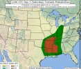
Severe Weather Threat - October 18th/19th 2025
- Thread starter WeathermanLeprechaun
- Start date

KakashiHatake2000
Member
convective chronicles is planning on going live talking about and or discussing the severe weather threat for saturday sunday timeframe 9:30 am tomorrow
KakashiHatake2000
Member
by the way jpwx what level are we on with your list you made the other day i believe sunday we were on number three last time
Tbf, it is an NSSL experimental product, and I actually like it for what it's intended for - it's an experimental ML modelling system with the goal of sniffing out medium-long range severe weather setups. Within the 3-day range it's not really useful because that's just not what it's for (unless you're tryna get clicks), but it seems to do pretty good overall.Exactly. Severe does not always equal tornados. It can be wind, hail etc.
We are between Number 5 and 8 currently @KakashiHatake2000
KakashiHatake2000
Member
oh i see gotcha thanks jpwx
KakashiHatake2000
Member
would take this probably with a grain of salt
Kds86z
Member
Kds86z
Member
Kds86z
Member
Kds86z
Member
Kds86z
Member
- Thread starter
- #34
WeathermanLeprechaun
Member
Discussed this issue last night with the setup. HRRR is overestimating low level shear imo though, but it's most likely going to be a 50-60 mph damaging wind producer. Maybe something drilling thru the stable layer is possible but highly unlikely.
- Thread starter
- #35
WeathermanLeprechaun
Member
It's meant for medium long range setups like you've said, and it's a great tool for getting the area of interest, but it doesn't determine any severe threat whatsoever in the short range.Tbf, it is an NSSL experimental product, and I actually like it for what it's intended for - it's an experimental ML modelling system with the goal of sniffing out medium-long range severe weather setups. Within the 3-day range it's not really useful because that's just not what it's for (unless you're tryna get clicks), but it seems to do pretty good overall.
- Thread starter
- #36
WeathermanLeprechaun
Member
The NAM3km is very bullish with kinematics, and once again this guy is doing these confusing not much context tweets with simulated IR making the system look really robust. These supercells will be dealing with poor low level shear, and this is exactly the stuff i hate when it comes to severe forecasting.
Low context posts that always make people think the wrong way about the setup. Really wish most just told it like it is, and didn't pick cherries out of a bias-ridden model LOL
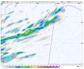
The hrrr has some rouge supercells ahead of the main squall for a decent bit of time today into Louisiana and Mississippi later tonight. That'll be something to watch
- Moderator
- #38
Never underestimate the ability of Alabama and/or Mississippi to pull a tornado out of even the weakest looking system. Not saying it will happen, but I won't be shocked if it does. That's not met speak - cause I'm not one - that's observation from being old(er).
akt1985
Member
Although I wish Alabama’s storm threat wasn’t overnight, it is good timing that the QLCS is coming after the Bama/UT game but before the race at Talladega.
- Thread starter
- #40
WeathermanLeprechaun
Member
Your area of Monroe County, MS may be able to avoid spinning up this time (major shock!) but i wouldn't be surprised if the presence of a storm alone near Amory causes a birdfart LOLWas just looking at the 00z HRRR.....
Sees Updraft Helicity Track.....
Laughs nervously on the inside.....
Things have got more interesting with this southern side of the system. Any line-supercell interactions in NE LA and into the overnight hours may be the trigger for tornadoes.The hrrr has some rouge supercells ahead of the main squall for a decent bit of time today into Louisiana and Mississippi later tonight. That'll be something to watch
A quick example is Enderlin. The line was why that supercell ramped up. Think of it as outflow or a haboob hitting the back of the cell. Suddenly
It's able to get surface based and drop tornadoes. Don't like saying that but my confidence is perhaps increasing in a few tornadoes around that area tonight