- Thread starter
- #41
WeathermanLeprechaun
Member
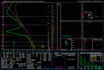
Just to give credence to my thinking - sounding reveals strong low level shear partially enhanced by the LLJ. The HRRR may be bullish with the shear just a bit but regardless still could produce tornadoes. My main problem is line orientation - a user shared a post earlier from someone discussing line orientation being the only thing really reducing the risk here. This has me personally think these supercell-line interactions are the watch tonight as they can significantly change the environment. Going toward 1-2am, this can get sneaky so anyone in the vicinity of Central/SW MS to Southern AL, keep weather radios on if you have one. Damaging wind and quick spinups as we all know is typical for Dixie but that doesn't mean they're harmless. Damaging winds up to 50-60 mph also plausible too with the line!