

- Thread starter
- #521
warneagle
Member
Unlike the severe threat, the high risk of excessive rainfall was very accurate.
Follow along with the video below to see how to install our site as a web app on your home screen.

Note: this_feature_currently_requires_accessing_site_using_safari
Looking back at the 2017 high risks... we aren't THAT far below most recent high risk tornado reports with yesterday. Should be more than 20. The difference is, most of them yesterday were outside the high risk. Sure, we had the potentially high end Mangum tornado and the gorgeous twins N of El Reno, which... would verify a slight at best. If not for the 45% and insane watch probs, this wouldn't have been quite as amazing a bust. As it stands it's the biggest 45%+ bust ever. With tornadoes from AZ to MO, some significant, it would've been quite the ENH outbreak, but still underwhelming even for a 30% day.
Of course, if the Mangum tornado is rated EF3 or higher, which is possible, that's actually one of the stronger tors we will have seen in our recent underwhelming high risks. The previous THREE highs didn't manage more than an EF2.
Looking back at the 2017 high risks... we aren't THAT far below most recent high risk tornado reports with yesterday. Should be more than 20. The difference is, most of them yesterday were outside the high risk. Sure, we had the potentially high end Mangum tornado and the gorgeous twins N of El Reno, which... would verify a slight at best. If not for the 45% and insane watch probs, this wouldn't have been quite as amazing a bust. As it stands it's the biggest 45%+ bust ever. With tornadoes from AZ to MO, some significant, it would've been quite the ENH outbreak, but still underwhelming even for a 30% day.
Of course, if the Mangum tornado is rated EF3 or higher, which is possible, that's actually one of the stronger tors we will have seen in our recent underwhelming high risks. The previous THREE highs didn't manage more than an EF2. Which may say a lot about either construction quality OR the events themselves.

I think the analysis of what the cap meant for the forecast may have been the result of confirmation bias—the assumption was that the main failure mode would be too many storms forming, not too few, so people took the stronger cap to mean that the main failure mode had been eliminated rather than seeing it as a potential failure mode in its own right. It didn’t help that none of the models really forecast a cap of that strength and that it wasn’t obvious in the early observations, but I think there was that preconceived idea of what a stronger-than-expected cap would mean.
I feel like there’s probably a debate to be had about over-reliance on CAMs and the tendency of social media to create feedback loops and promote groupthink as well, but that struck me as the most obvious issue with the nowcasting yesterday evening.
I don’t think they were wrong to go with the high risk given the model output and observed conditions yesterday, but I do think they may have communicated more confidence in the forecast than was actually realistic (particularly in the extreme probabilities in the two PDS watches). You’re never going to get it 100% right and you’ll inevitably be criticized whether your forecast underperforms or overperforms, but being transparent about uncertainty and communicating the level of confidence accurately takes some of the sting out of those criticisms. Hopefully this will be a learning experience both scientifically (still mind-blowing that a day with those parameters busted) and in terms of communication/public relations.
Also, with the comparison of outlooks/PDS watch probs between 4/27/2011 and yesterday, the 45% tornado contour was actually a bit larger in the 1630z SPC outlook for yesterday compared to the same outlook from 4/27/2011. I'm not sure what exactly to make out of that, but it is an interesting comparison and interesting to look at.
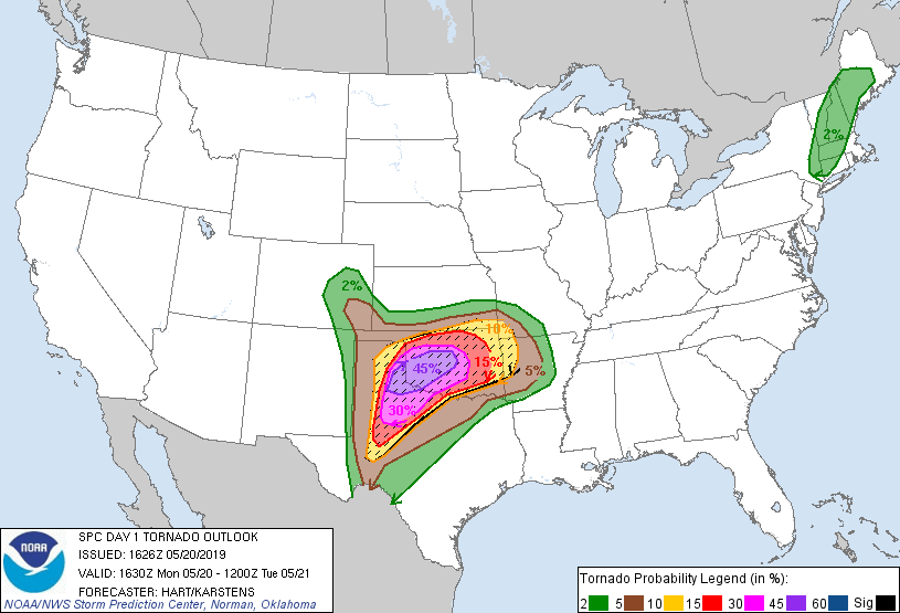
5/20/2019:
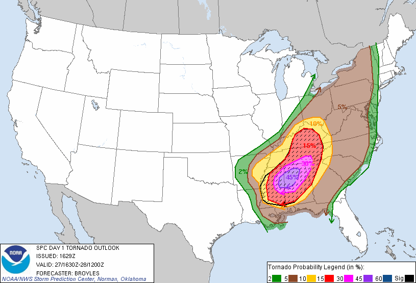
4/27/2011:

Nearly 50 Million People Under Threat of Severe Weather 21st Through 26th. Severe Thunder Storms, Damaging Winds, Flooding, and Isolated Tornados and Severe Hail, Can Not Be Ruled out. These Storms Have Strawn out some very strong Tornados in the passed hours. I urge everyone whom lives in the above States To Be Planning Their Safe Shelters Now. ( STAY SAFE )