• Welcome to TalkWeather!
    We see you lurking around TalkWeather! Take the extra step and join us today to view attachments, see less ads and maybe even join the discussion.
    CLICK TO JOIN TALKWEATHER
Logo 468x120

Severe WX March 30th- April 1st 2023 (South, Southeast, Ohio Valley, Upper Midwest)

jiharris0220

Member
Messages
200
Reaction score
536
Location
Wichita Falls
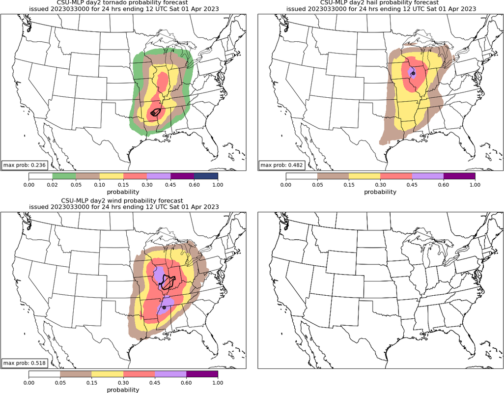
It’s one thing if a single cam shows a risk for long track tornadoes, it’s a whole other ball game if every single cam is showing the same thing.
The take away from all of this at least currently is that there’s not one scenario across all cams that doesn’t show a long track SigT risk.
 

CCAir90

Member
Messages
2
Reaction score
15
Location
Jackson, TN
HAM Callsign
KJ4WMW
Special Affiliations
  1. SKYWARN® Volunteer
I know Arkansas is 10% which is high, but I don’t understand why it’s not higher or on par with the northern risk area.

I think any cells that fire down there will be able to remain discrete for a longer period of time than any up north, with the deeper shear vectors favoring a more discrete mode at first, and with access to some really good parameters. However, that’s only my opinion.
Nadocast on Twitter did say after last week that the model likely is mostly shear-driven and isn't great at distinguishing/discriminating based upon storm mode. I think that's the reason for the skew we see this week, too.

Screenshot_20230330-111348~2.png
 

UncleJuJu98

Member
100,000th Post
Messages
3,920
Reaction score
5,096
Location
Birmingham
Nadocast on Twitter did say after last week that the model likely is mostly shear-driven and isn't great at distinguishing/discriminating based upon storm mode. I think that's the reason for the skew we see this week, too.

View attachment 19343
Yes it's very shear driven. The plains derecho from last month maybe? Or early this march had low cape but extreme shear and nado cast went nuts. If I remember correctly it was spitting out like 60% tornado probs lol.

Or maybe that was wind threat I can't remember exactly haha
 

UncleJuJu98

Member
100,000th Post
Messages
3,920
Reaction score
5,096
Location
Birmingham
Yes it's very shear driven. The plains derecho from last month maybe? Or early this march had low cape but extreme shear and nado cast went nuts. If I remember correctly it was spitting out like 60% tornado probs lol.

Or maybe that was wind threat I can't remember exactly haha
*Correction* went back and looked I was wrong on the 60% just checked. it maxed out at 15% it did fairly well.
 

ColdFront

Member
Messages
541
Reaction score
1,131
Location
Arctic
Yes it's very shear driven. The plains derecho from last month maybe? Or early this march had low cape but extreme shear and nado cast went nuts. If I remember correctly it was spitting out like 60% tornado probs lol.

Or maybe that was wind threat I can't remember exactly haha
Yeah that really nasty QLCS that hit Norman
 

UncleJuJu98

Member
100,000th Post
Messages
3,920
Reaction score
5,096
Location
Birmingham
The RAP continues to indicate best paramters area being parts of central into north Mississippi.

I think your going to start trending to a more widespread significant severe into much of north Mississippi and parts of northern central Mississippi
 

UncleJuJu98

Member
100,000th Post
Messages
3,920
Reaction score
5,096
Location
Birmingham
Not as bad (as of now) don't see it being as bad here kindve a sharp cutoff may have a severe storm or two or a spin up I would think.
I just hope there isn't a Alabama wobble, I think we are too close to really see that though. If we did have any significant it would clip that northwest part of Alabama but I'm not sure how likely that'll happen.
 

JayF

Technical Administrator
Staff member
Administrator
Moderator
Sustaining Member
Technical Admin
Messages
1,626
Reaction score
883
Location
Hartselle, al
HAM Callsign
KB4JCS
Not as bad (as of now) don't see it being as bad here kindve a sharp cutoff may have a severe storm or two or a spin up I would think.
I don't know they are on the edge of the Enhanced outlook. That is exactly where they were last week.
@The Nino and @cheestaysfly As always stay weather aware. This forum is pretty good about keeping up with where the storms are going. I know when we have severe weather, I am stuck to the radars.
 

UncleJuJu98

Member
100,000th Post
Messages
3,920
Reaction score
5,096
Location
Birmingham
I don't know they are on the edge of the Enhanced outlook. That is exactly where they were last week.
@The Nino and @cheestaysfly As always stay weather aware. This forum is pretty good about keeping up with where the storms are going. I know when we have severe weather, I am stuck to the radars.
Good point there lol, that's why you should always follow your local weather man haha
 

JayF

Technical Administrator
Staff member
Administrator
Moderator
Sustaining Member
Technical Admin
Messages
1,626
Reaction score
883
Location
Hartselle, al
HAM Callsign
KB4JCS
Good point there lol, that's why you should always follow your local weather man haha
Or just keep an eye here and the weatherman so you get all of the details. :)
 

Taylor Campbell

Moderator
Moderator
PerryW Project Supporter
Messages
2,110
Reaction score
2,209
Location
Wedowee, AL
Special Affiliations
  1. SKYWARN® Volunteer
I'm most concerned of the tornado potential on the southern threat. Hodographs have good curvature across the eastern half of AR towards northern MS, and the Memphis metro area. SARS shows significant tornado analog matches and enhanced probabilities for EF3-EF4 type tornado potential amid discrete like activity. This area is best denoted by the CSU-MLP forecast map.

C49-A72-A7-0-C22-4092-A25-C-0-F537-EA696-CD.png
 
Last edited:

cincywx

Member
Messages
441
Reaction score
797
Location
Cincinnati, OH
Special Affiliations
  1. SKYWARN® Volunteer
643a70a63527f79f1b259a496c551661.jpg


DAY 2 CONVECTIVE OUTLOOK
NWS STORM PREDICTION CENTER NORMAN OK
1232 PM CDT THU MAR 30 2023

VALID 311200Z - 011200Z

...THERE IS A MODERATE RISK OF SEVERE THUNDERSTORMS ACROSS EASTERN
IOWA INTO NORTHWEST ILLINOIS AND FAR NORTHEAST MISSOURI...AND ALSO
ACROSS NORTHEAST ARKANSAS...THE MISSOURI BOOTHEEL...EXTREME WESTERN
KENTUCKY...WESTERN TENNESSEE...AND FAR NORTHWEST MISSISSIPPI...

..SUMMARY

INTENSE AND WIDESPREAD SEVERE THUNDERSTORMS ARE EXPECTED FRIDAY
AFTERNOON INTO THE OVERNIGHT HOURS ACROSS PORTIONS OF THE MIDDLE
MISSISSIPPI VALLEY AND MID-SOUTH VICINITY, EASTWARD TO THE LOWER
OHIO AND TENNESSEE VALLEYS. INTENSE, DAMAGING GUSTS AND SEVERAL
TORNADOES (SOME STRONG AND LONG-TRACK) ARE EXPECTED.

...A REGIONAL OUTBREAK OF SEVERE STORMS IS EXPECTED ON FRIDAY ACROSS
PARTS OF THE MID-MISSISSIPPI VALLEY AND ALSO INTO THE MID-SOUTH...

..SYNOPSIS

A DEEP MID/UPPER-LEVEL TROUGH AND ATTENDANT 100 KT MIDLEVEL JET WILL
MOVE QUICKLY EASTWARD FROM THE CENTRAL PLAINS INTO PARTS OF THE MS
VALLEY AND MIDWEST ON FRIDAY. A SURFACE LOW WILL DEEPEN AS IT MOVES
ACROSS IA TOWARD THE GREAT LAKES REGION, AS A COLD FRONT SWEEPS
EASTWARD THROUGH PARTS OF THE GREAT PLAINS INTO THE MID-MS VALLEY.
IN ADVANCE OF THE COLD FRONT, LOW-LEVEL MOISTURE WILL STREAM
NORTHWARD ACROSS A BROAD WARM SECTOR FROM THE ARKLATEX REGION INTO
PARTS OF THE LOWER/MID MS VALLEY AND MIDWEST.

..MID-MS VALLEY VICINITY INTO IN/LOWER MI

RAPID DESTABILIZATION AND INCREASING LARGE-SCALE ASCENT WILL SUPPORT
THUNDERSTORM DEVELOPMENT BY EARLY/MID AFTERNOON ACROSS PARTS OF IA
INTO NORTHERN MO. VERY STRONG DEEP-LAYER SHEAR (EFFECTIVE SHEAR IN
EXCESS OF 60 KT) AND MLCAPE INCREASING TO 1000-1500 J/KG (LOCALLY
GREATER) WILL SUPPORT ORGANIZED CONVECTION, WITH INITIAL SUPERCELL
DEVELOPMENT EXPECTED SOMEWHERE OVER CENTRAL IA INTO NORTH-CENTRAL
MO. VERY LARGE HAIL WILL BE THE INITIAL THREAT, GIVEN STEEP MIDLEVEL
LAPSE RATES AND COLD TEMPERATURES ALOFT.

SOME UNCERTAINTY REMAINS REGARDING THE CONVECTIVE MODE EVOLUTION
WITH TIME, BUT A FEW SEMI-DISCRETE SUPERCELLS ARE EXPECTED TO MOVE
INTO AN ENVIRONMENT WITH STRONGER LOW-LEVEL SHEAR/SRH ACROSS EASTERN
IA INTO NORTHWEST IL BY LATE AFTERNOON, POSING A THREAT FOR A COUPLE
STRONG TORNADOES. EVOLUTION INTO SMALL CLUSTERS OR BOWING SEGMENTS
IS EXPECTED, RESULTING IN AN INCREASING THREAT OF SEVERE/DAMAGING
WINDS IN ADDITION TO A CONTINUED THREAT OF A FEW TORNADOES AND
SPORADIC HAIL.

ORGANIZED CONVECTION WILL SPREAD EASTWARD INTO PARTS OF IN/SOUTHERN
MI FRIDAY NIGHT. INSTABILITY WILL WEAKEN WITH EASTWARD EXTENT, BUT
SOME THREAT FOR DAMAGING WIND AND A COUPLE OF TORNADOES WILL PERSIST
BEFORE A MORE DEFINITIVE WEAKENING TREND OCCURS OVERNIGHT INTO EARLY
SATURDAY MORNING.

..ARKLATEX/MID SOUTH VICINITY INTO THE TN/LOWER OH VALLEYS

A CONCERNING SCENARIO STILL APPEARS POSSIBLE ACROSS PORTIONS OF THE
MO BOOTHEEL, NORTHEAST AR, WESTERN TN/KY AND FAR NORTHWEST MS
VICINITY DURING THE AFTERNOON/EVENING. AT LEAST MID-60S F DEWPOINTS
ARE EXPECTED BENEATH MODEST MIDLEVEL LAPSE RATES. THIS WILL SUPPORT
1500-2000 J/KG MLCAPE AMID INTENSE VERTICAL SHEAR. FORECAST
SOUNDINGS INDICATE 0-1 KM SRH INCREASING TO AROUND 400 M2/S2 BY
EARLY AFTERNOON. THUNDERSTORMS ARE EXPECTED TO DEVELOP BY EARLY
AFTERNOON AHEAD OF THE COLD FRONT WITHIN A PRE-FRONTAL
TROUGH/LOW-LEVEL CONFLUENCE ZONE. STORM MOTION NEAR 50 KT WITH
SUPERCELL WIND PROFILES WILL SUPPORT CELLS CAPABLE OF SIGNIFICANT
AND LONG-TRACK TORNADOES. WITH TIME, UPSCALE GROWTH INTO A QLCS IS
EXPECTED, AND INTENSE WIND GUSTS WILL BE POSSIBLE IN ADDITION TO
MESOVORTEX TORNADOES. THE THREAT FOR DAMAGING GUSTS AND A FEW
LINE-EMBEDDED TORNADOES WILL SPREAD INTO PARTS OF THE TN AND LOWER
OH VALLEYS FRIDAY NIGHT, WITH A GRADUAL WEAKENING TREND EVENTUALLY
EXPECTED OVERNIGHT AS STORMS MOVE INTO INCREASINGLY WEAK BUOYANCY
WITH EASTWARD EXTENT.

..DEAN.. 03/30/2023
 
Back
Top