
Thread related to Hurricane Hilary
Navigation
Install the app
How to install the app on iOS
Follow along with the video below to see how to install our site as a web app on your home screen.
Note: This feature may not be available in some browsers.
More options
-
Welcome to TalkWeather! We see you lurking around TalkWeather! Take the extra step and join us today to view attachments, see less ads and maybe even join the discussion. CLICK TO JOIN TALKWEATHER
You are using an out of date browser. It may not display this or other websites correctly.
You should upgrade or use an alternative browser.
You should upgrade or use an alternative browser.
Hurricane Hurricane Hilary
- Thread starter JBishopwx
- Start date
- Thread starter
- #2
- Thread starter
- #3


- Thread starter
- #4

Thanksgivingbrown
Member
Some of the flooding occurring in Mexico
https://x.com/astiller0/status/1693059503242072068?s=46&t=qKcCMht4HocyNrVsAzPVfg
https://x.com/astiller0/status/1693059503242072068?s=46&t=qKcCMht4HocyNrVsAzPVfg
Last edited:
akt1985
Member
If Hillary was occurring between Gulf Shores and Panama City, it would not be nearly the big deal it’s getting hitting the California coast. Could that be enough to get the name retired?
Thanksgivingbrown
Member
Tornado threat has increased 
TH2002
Member
- Messages
- 4,969
- Reaction score
- 11,103
- Location
- California, United States
- Special Affiliations
- SKYWARN® Volunteer
Tornado threat should stay to my east but the rain is on. Latest forecast calls for 3-4'' downtown but could get up to 5'' here.
Los Angeles under a FFW.
Flash Flood Warning
CAC037-111-210245-
/O.NEW.KLOX.FF.W.0020.230820T1848Z-230821T0245Z/
/00000.0.ER.000000T0000Z.000000T0000Z.000000T0000Z.OO/
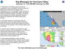
BULLETIN - EAS ACTIVATION REQUESTED
Flash Flood Warning
National Weather Service Los Angeles/Oxnard CA
1148 AM PDT Sun Aug 20 2023
The National Weather Service in Los Angeles/Oxnard has issued a
* Flash Flood Warning for...
Southern Los Angeles County in southwestern California...
Southeastern Ventura County in southwestern California...
* Until 745 PM PDT Sunday.
* At 1148 AM PDT, Doppler radar and rain gauge reports indicated
heavy rain across the warned area. Rainfall rates of 0.5 to 1 inch
per hour will be common.. Additional rainfall amounts of 1 to 3
inches are possible in the warned area. Heavier rainfall with
embedded thunderstorms are expected this afternoon and evening,
with local rates up to 1.5 inches per hour possible. Flash
flooding is ongoing or expected to begin shortly.
HAZARD...Dangerous life threatening flash flooding is expected.
SOURCE...Radar.
IMPACT...Life threatening flash flooding of creeks, streams,
and normally dry arroyos are expected. Significant
urban roadway flooding will occur, especially in low
lying areas. Dangerous flows will likely occur across
low water crossings. Significant rock and mudslide
activity is expected in the mountains and canyons,
with debris flows possible in recent burn scars.
* Some locations that will experience flash flooding include...
Long Beach, Thousand Oaks, Simi Valley, Malibu, Hollywood, Beverly
Hills, Universal City, Downtown Los Angeles, Griffith Park, Culver
City, Inglewood, Burbank, North Hollywood, Venice, Santa Monica,
Van Nuys, Encino, Manhattan Beach, Alhambra and Hermosa Beach.
PRECAUTIONARY/PREPAREDNESS ACTIONS...
Turn around, don`t drown when encountering flooded roads. Most flood
deaths occur in vehicles.
Be aware of your surroundings and do not drive on flooded roads.
In hilly terrain there are hundreds of low water crossings which are
potentially dangerous in heavy rain. Do not attempt to cross flooded
roads. Find an alternate route.
&&
LAT...LON 3412 11908 3417 11867 3424 11863 3425 11863
3430 11868 3429 11911 3440 11861 3433 11852
3417 11806 3415 11768 3395 11778 3395 11798
3376 11809 3371 11823 3377 11828 3370 11829
3374 11841 3398 11844 3403 11853 3400 11881
FLASH FLOOD...RADAR INDICATED
FLASH FLOOD DAMAGE THREAT...CONSIDERABLE
EXPECTED RAINFALL RATE...0.5-1 INCH IN 1 HOUR
$$
Sirard
Thanksgivingbrown
Member
Los Angeles , which is under a tropical storm warning, just had an earthquake to boot.
TH2002
Member
- Messages
- 4,969
- Reaction score
- 11,103
- Location
- California, United States
- Special Affiliations
- SKYWARN® Volunteer
Oklahoma: home of the quakenado
California: home of the hurriquake
California: home of the hurriquake
TH2002
Member
- Messages
- 4,969
- Reaction score
- 11,103
- Location
- California, United States
- Special Affiliations
- SKYWARN® Volunteer
Locally, the impacts from Hilary were more or less akin to the atmospheric rivers we sometimes see during the wintertime. Some mud and small rocks on the roads but that's about it. A bit further up in the mountains (Big Bear, Julian, etc.) seeing reports of some debris flows. The worst of the storm's impacts were in the deserts:
- Thread starter
- #14