• Welcome to TalkWeather!
    We see you lurking around TalkWeather! Take the extra step and join us today to view attachments, see less ads and maybe even join the discussion.
    CLICK TO JOIN TALKWEATHER

Forecasting geological disasters

bjdeming

Member
Sustaining Member
Messages
2,071
Reaction score
1,866
Location
Corvallis, Oregon
JAMA has lifted the alert. They have taken a lot of criticism for it -- as far as I can see, many critics have been people who would complain just as hard, and with much the same words, had JMA not issued its special warning and a megaquake had happened.

Here is a critique from an earthquake risk source. From what little I've seen online, because of the alert many Japanese are starting to think about what they would do in the event and almost half of those interviewed in one study approved of the alert.

The geological and social situation reminds me of the 1980 Mammoth Mountain crisis, which is why I thought a thread might be appropriate (and also because of member interest in forecasting events). Today, CALVO considers those volcanoes a moderate risk.

Which is more important in triggering a forecast: the probability of a hazard or the potential costs, human and material, if it does happen?
 

slenker

Member
Messages
215
Reaction score
484
Location
Columbus, OH
JAMA has lifted the alert. They have taken a lot of criticism for it -- as far as I can see, many critics have been people who would complain just as hard, and with much the same words, had JMA not issued its special warning and a megaquake had happened.

Here is a critique from an earthquake risk source. From what little I've seen online, because of the alert many Japanese are starting to think about what they would do in the event and almost half of those interviewed in one study approved of the alert.

The geological and social situation reminds me of the 1980 Mammoth Mountain crisis, which is why I thought a thread might be appropriate (and also because of member interest in forecasting events). Today, CALVO considers those volcanoes a moderate risk.

Which is more important in triggering a forecast: the probability of a hazard or the potential costs, human and material, if it does happen?
Personally, I don’t understand why a strongly-worded warning that ends up “busting” or not panning out to be high-end event, for any mode of natural disaster ends up being bashed. They use probabilities for these events for a reason, it’s because things are almost never going to happen with 100% certainty. It happens with both weather and stuff like this.

Like you said, what if it did happen and they didn’t send out a warning, or sent out a downplayed warning? Then the blame is very rightfully on them. Experts know more than a layman, and if they get a high-end forecast for any event wrong in the sense that nothing bad ends up happening, why are people still upset rather than happy bad things didn’t happen? If it was easy to forecast a natural disaster of horrible proportions then we would never have used the word “bust” to begin with for these events.

It’s never a bad idea to be prepared for any natural disaster, even without a warning/watch being in place, if you live in an area that is prone to being struck by said disaster. I feel like this shouldn’t really be a debate either. I blame the fact that a substantial portion of people likely have the wrong idea about how these warnings/watches work.
 

bjdeming

Member
Sustaining Member
Messages
2,071
Reaction score
1,866
Location
Corvallis, Oregon
I blame the fact that a substantial portion of people likely have the wrong idea about how these warnings/watches work.

Bingo! For instance, when I'm reading papers, one of the issues volcanologists raise over and over again is that most people do not understand probability. We mistake a warning for a prediction (which is impossible).
 

bjdeming

Member
Sustaining Member
Messages
2,071
Reaction score
1,866
Location
Corvallis, Oregon
In quite another part of the world, the Caribbean, major tsunamis are a concern from earthquakes and volcanoes (and there, as in the Gulf and elsewhere near populated coasts, from submarine slumps and other mass movements, but as I understand it, those are not at all predictable).

Warning time is crucial and there are the DART buoys and so forth, but tsunamis from volcanic eruptions are extremely complex and hard to predict -- I was just reading an open-access paper about forecasting volcanic tsunamis (for a Krakatoa blog post series) and came across this section on the Caribbean.

Don't know if it has been implemented, but if someone is vacationing there and hears that a VONUT has been issued, head for high ground or the top floors at a resort, NOT to Krispy Kreme! ;)

6.5 Caribbean Tsunami Warning Procedures Using Volcano Notice of Tsunami Threat (VONUT)(UNESCO/IOC)​

In the Caribbean, 27% (16 of 59) of the tsunamis reported as “probable” or “definite” in the NCEI/WDS database were generated by volcanoes (Dunbar et al. 2008; NOAA, NCEI/WDS 2023), Recent eruptions of Kick’em Jenny (2015, 1965, 1939), Soufriere volcano on Saint Vincent (2021, 2020, 1902) and Mount Pelée on Martinique (1902), and Soufriere Hills in Montserrat (2006, 2003, 1999) have raised awareness on the potential tsunami hazard.

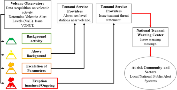
In 2023 as part of the CARIBEWAVE tsunami exercise (UNESCO/IOC 2023, www.caribewave.info), the UNESCO/IOC Intergovernmental Coordination Group for the Tsunami and other Coastal Hazards Warning Systems tested the use of a Volcano Observatory Notice for tsUnami Threat (VONUT) message (Clouard et al., 2024). The VONUT is derived from the Volcano Observatory Notice for Aviation (VONA) bulletin. Volcano observatories issue the initial VONUT to the CARIBE-EWS Tsunami Service Providers (Pacific Tsunami Warning Center, and starting in 2024 Central American Tsunami Advisory Center) to advise them of heightened volcanic activity indicative of an impending eruption and the potential for tsunami generation (Fig. 24). This alerts the TSPs, who can then monitor the sea-level gauges nearest the volcano, and pre-compute tsunami travel times from the volcano to nearby coasts. The second VONUT is issued if the eruption occurs. If tsunami waves are observed on the nearest sea-level gauges, then the TSP will issue a tsunami threat message to Member State NTWCs. The threat message will advise on the eruption and tsunami, and give computed estimated times of arrival (ETA) at nearby locations. Subsequent TSP messages would report on the location, time and amplitude of observed tsunami waves. This continues until the threat has passed. Currently there is no capability to provide a tsunami forecasts in the VONUT threat messages.

Figure 24
figure 24
CARIBE-EWS proposed system for issuing alerts about tsunamis generated by volcanoes. The color codes of the volcano pictograms are the same as those in the VONA
 

bjdeming

Member
Sustaining Member
Messages
2,071
Reaction score
1,866
Location
Corvallis, Oregon
In theory, by factoring in effects people learned about in January 2022, Kick-'em-Jenny (nobody apparently knows the name's origin) and/or some lesser known to unknown submarine Caribbean volcano could have a surprisingly long reach:

...For example, the underwater volcano known as Kick'em Jenny is thought to pose only a regional tsunami risk to the neighboring Caribbean island of Grenada. But in fact "it may very well excite the entire Caribbean and Gulf of Mexico, and possibly even the Atlantic and global oceans, if a Tonga-type event were to happen", he said.

-- Source

That's a BIG "if." They're still intensively studying the Hunga Tonga (HTHH) blast (and Krakatoa 1883, as best they can) and I don't know of any broad consensus on the causes of either of those two biggies.

It's a huge area of research since 2022 precisely because of the HTHH wake-up call on submarine volcanoes everywhere.

K-e-J is between St. Vincent and Martinique Grenada, fairly big, just below sea level, active a lot but, unlike Hunga Tonga or Krakatoa pre-1883 and post-1930, truly submarine.

There are no rocky islands nearby marking an old caldera rim. (Edit: On re-reading the GVP story, it does have what could be a submarine volcanic complex -- no mention of a caldera, though.)

Its vent is far enough below the surface to mostly just roil up the water and cause problems with toxic gas release. It has built a couple temporary islands, I think, but that's all.
 
Last edited:

bjdeming

Member
Sustaining Member
Messages
2,071
Reaction score
1,866
Location
Corvallis, Oregon
The USGS/Yellowstone Volcano Observatory gets into forecasting eruptions this week with this article.

They use a baseball analogy, but as this MUCH more technical paper on probability mentions, they would like to achieve weather-forecast reliability.
 

bjdeming

Member
Sustaining Member
Messages
2,071
Reaction score
1,866
Location
Corvallis, Oregon
Came across this video on potential ash distribution of a Yellowstone supereruption across the country, while working up a blog post, and learned that high-end eruptions (VEI 8) can modify wind fields across a continent!

As he says, after a terrific introduction by Dr. Jake Lowenstern, then the Yellowstone Volcano Observatory Scientist In Charge, it's an academic matter and there is no reason to think one will occur at Yellowstone during our lifetime, but it's an interesting nerdy talk that blends volcanology and a little meteorology:


The paper is open access.

(In terms of practical disaster forecasting, they mention that volcano observatories can get ash forecasts for their local volcano emergency online.)
 

bjdeming

Member
Sustaining Member
Messages
2,071
Reaction score
1,866
Location
Corvallis, Oregon
learned that high-end eruptions (VEI 8) can modify wind fields across a continent!

Or perhaps, on watching it again, that supereruption plumes are not influenced by the winds.

Anyway, he shows an umbrella cloud from Calbuco (where he's talking about satellite views and testing the Yellowstone model against those), and a little reading later in the day about how volcanoes entrain air to build a plume reminded me of the video someone made that captured the start of that plinian eruption.

Since folks are into convection and clouds here :) , thought it might be fun to include both that video and the description from the paper I was reading (there's some cussing in the video):


What's going on: Inside Calbuco, rising magma fragmented into bits down in the conduit, becoming a high-velocity rock foam that shot upward and happened to erupt while someone had their camera on the volcano.

Being denser than air, momentum alone wouldn't have taken it very high.

But then:

...once the mixture emerges as a jet into the atmosphere, interaction with the air generates high eruption plumes and/or pyroclastic density currents...the fundamental process of interaction is turbulent air entrainment into the high-speed erupting mixture; this has two major consequences. First, entrainment of air decelerates the ascending mixture by momentum transfer (the entrained air has to be accelerated). Second, the entrained air is heated, and the mixture density reducesas the plume rises. As erupting mixtures are almost always denser than air, they typically have enough initial kinetic energy to rise only hundreds of meters to a few kilometers into theatmosphere. Thus, formation of the towering convecting eruption columns commonly seen in Plinian eruptions requires air entrainment and heating of the air by the volcanic particles. This process generates potential energy by converting thermal energy in the magma to mechanical energy through buoyancy of the mixture. Typically, thermal energy is more than an order of magnitude greater than the kinetic energy.

-- Source: Cashman, K. V., & Sparks, R. S. J. (2013). How volcanoes work: A 25 year perspective. Bulletin, 125(5-6), 664-690.

That's what Dr. Mastin was talking about in the Q&A when he said heat drives the plume.
 

Sawmaster

Member
Messages
696
Reaction score
1,002
Location
Marietta SC
Special Affiliations
  1. SKYWARN® Volunteer
I nominate "Volconvection" as the next word to add to our scientific vocabulary ;)

That was a very lucky vid catch reminding us that there's still a lot we can learn about our planet.
 

bjdeming

Member
Sustaining Member
Messages
2,071
Reaction score
1,866
Location
Corvallis, Oregon
That was a VEI 4 eruption -- a VEI 8 (supereruption), in general, would be 10,000 times bigger.

As I understand it, VEI 8's are basically ash flow eruptions -- a hurricane of huge pyroclastic flows. Those flows spawn convective columns that feed the umbrella cloud and probably spread over at least 100 km in all directions.

I wonder how that broad-based area of sustained convection extending into the lower stratosphere would affect tropospheric atmospheric circulation patterns over the region/continent (without factoring in other things like cooling from the umbrella shade, and eventual stratospheric sulfur aerosol global climate effects).

A lot depends on eruption duration, and this is one of the big unknowns for any supereruption. One estimate was about 90 hours for Long Valley's Bishop Tuff eruption, whose deposits are all over the Southwest and coastal areas, but it might be longer in supereruptions, too -- a week or more of that intense convection (though possibly coming in spurts until the presumed climactic caldera collapse).

Of course, nobody's going to be thinking about the weather forecast at that point. Glad it's just an academic question (hopefully).
 
Back
Top