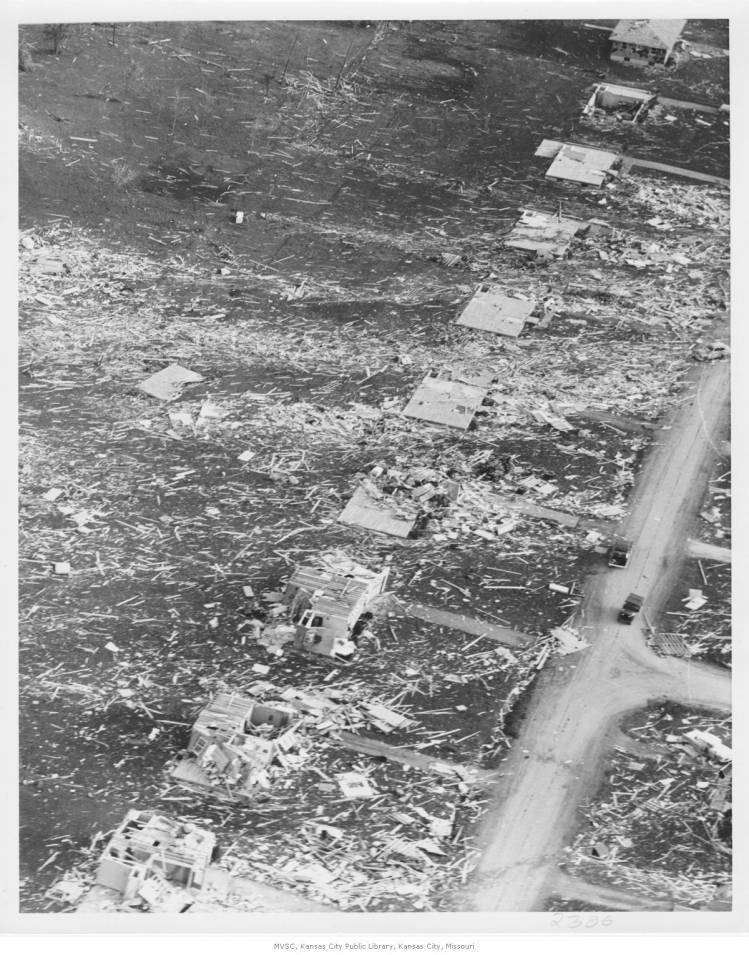
• Welcome to TalkWeather!
    We see you lurking around TalkWeather! Take the extra step and join us today to view attachments, see less ads and maybe even join the discussion.
    CLICK TO JOIN TALKWEATHER

WesL

"Bill, I'm talkin' imminent rueage"
Staff member
Administrator
Moderator
Sustaining Member
Messages
3,341
Reaction score
2,609
Location
Fayetteville, AR
Special Affiliations
  1. SKYWARN® Volunteer
That is some pretty impressive damage. Looking at those cars you can see how they just rolled and rolled. Scary stuff, especially with little or no warning. I think we all take that for granted today.
 

SGFmoTwister

Member
Messages
38
Reaction score
50
Location
Springfield, Missouri, USA
download x.png
1712
1713
60594057_10156809768306311_2587005462629056512_n.jpg
 

andyhb

Member
Messages
1,030
Reaction score
2,674
Location
Norman, OK
Interesting to note the anchor bolts in the pictures from Hickman Mills.
 
Messages
2,151
Reaction score
2,703
Location
Missouri
The scariest thing to me about this tornado is this pic:

1_-_Map.jpg

This tornado was in 1957, when the Kansas City metro area was largely rural with a spattering of small suburban developments, as you can see if you look in the upper right of the pic. If this tornado were to occur today & take the same path, the damage and death toll would undoubtedly be much higher than it was back then. KC is another one of those probable worst case scenarios for an F5 tornado hitting a densely populated urban area, especially during rush hour.
 

SGFmoTwister

Member
Messages
38
Reaction score
50
Location
Springfield, Missouri, USA
I'd love to find these books...

39424bc0.jpg

EYdjUdiUEAcAVwn.jpg

The house in the 'car in the basement' pics is under the 'U.S. 71' label on the map. The damage in this section of Hickman Mills is just as bad as the Ruskin Heights stuff. It's tragic the tornado seem to strengthen back to full force, grow in size, and turn north, then northeast to plow into those two areas.
248699_174753599248798_3370151_n.jpg

P8581W.jpg

DamagePic20_JoyceRew.jpg

Noname17.jpg

0521570030zsfx.gif

Tornado3.jpg

getimagek.jpg

getimageo.jpg
 

buckeye05

Member
Messages
3,120
Reaction score
4,581
Location
Colorado
Interesting to note the anchor bolts in the pictures from Hickman Mills.
Yup. Always felt that a majority of the damage from this one could be classified as EF4. However, there were a few homes that had their bolted-down subfloors ripped from the anchor bolts, leaving the basements exposed. These few homes could be classified as isolated spots of genuine EF5 damage among a sea of EF4 imo. Another such house is visible one house down from the top in this pic as well (already posted above). Note the near complete lack of debris at that particular home as well compared to the others.
4619_6eaec0bedc0e6626cc824a60db849ff5.jpg


Another photo from the same area of Ruskin Heights showing additional likely EF5 damage to two other nearby homes.
view


Harder to see, but more EF5 candidates visible in this pic too.
view
 
Last edited:
Messages
2,734
Reaction score
4,239
Location
Madison, WI
Again, the Chuck LeMaster/Ottawa Herald photos strongly resemble several of the tornadoes from 4/27/11, particularly the Cordova tornado and the Cullman tornado in its later stages, with that practically ground-scraping updraft base/wall cloud pendant from a large rain-free base; and easily mistaken for a much larger tornado from a distance where the space between it and the ground is obscured by hills/trees.
 
Messages
2,151
Reaction score
2,703
Location
Missouri
Again, the Chuck LeMaster/Ottawa Herald photos strongly resemble several of the tornadoes from 4/27/11, particularly the Cordova tornado and the Cullman tornado in its later stages, with that practically ground-scraping updraft base/wall cloud pendant from a large rain-free base; and easily mistaken for a much larger tornado from a distance where the space between it and the ground is obscured by hills/trees.
I have a feeling the Tri-State had a similar set up, with many of the descriptions of it being a big cloud moving along the ground, the hilly terrain of Dixie Alley makes it easier for the wall clouds to be mistaken for the tornado, whereas Ruskin Heights occurred in the flatter 'traditional' (for lack of a better word) Tornado Alley making it easier to see the funnel below. It also has a rather long path length for a tornado in this region of the country, it also touched down around dusk in Kansas and struck the KC area around 7:30, after dark, again, like many Dixie events.
 
Last edited:
Messages
2,151
Reaction score
2,703
Location
Missouri
I'd love to find these books...

View attachment 4589

View attachment 4594

The house in the 'car in the basement' pics is under the 'U.S. 71' label on the map. The damage in this section of Hickman Mills is just as bad as the Ruskin Heights stuff. It's tragic the tornado seem to strengthen back to full force, grow in size, and turn north, then northeast to plow into those two areas.
View attachment 4604

View attachment 4598

View attachment 4592

View attachment 4595

View attachment 4596

View attachment 4600

View attachment 4602

View attachment 4603
Those two books both seem highly out of print, only a single used copy for $100 on Amazon, and in 'acceptable' condition at that....I'm sure if you traveled to the Kansas City area you could find them at many of the libraries or historical society museums there. I'm not sure if they're worth getting a hold of though, as I bet all the photographs in them are easily available via digital archives and the like.
Also, regarding your quote "It's tragic the tornado seem to strengthen back to full force, grow in size, and turn north, then northeast to plow into those two areas", is the consensus that it was a single tornado or could it have been a closely spaced family of two or three? The reason I ask is because it has a rather long path length for a Central Plains event (~70 miles).
 

SGFmoTwister

Member
Messages
38
Reaction score
50
Location
Springfield, Missouri, USA
To me 'Ruskin Height' seems like Moore 1999 in that it clearly went through several cycles during its lifespan. So, I think it was the same tornado, but different vortices being more dominate than others at times. Just a guess. It changed appearance quite often, so it's hard to tell. I wish we had some video footage of it or even more pictures. Too bad that no photos of it while in Hickman Mills/Ruskin Heights exist. It seems to be as wide in that area as it had been near Spring HIll, KS, so I've always imagined it looking like it does in that scary picture when going through Ruskin Heights.

Actually, I think it was still somewhat light at that time...it wouldn't be all that dark until about 8-8:30 in late May in Missouri. I think the Hickman Mills/Ruskin Heights people had a good look at it...too good of a look for the people in its path!!!

A lot of the information from people recounting its appearance have commented on how different it looked depending on where you were located. If the sun was behind you it looked a certain way, but if you were in front of the sun it changed yet again and then the people who were north/south of it described yet a third appearance to the funnel.
 
Logo 468x120
Back
Top