• Welcome to TalkWeather!
    We see you lurking around TalkWeather! Take the extra step and join us today to view attachments, see less ads and maybe even join the discussion.
    CLICK TO JOIN TALKWEATHER

Severe WX Severe Weather Threat May 22-24, 2026

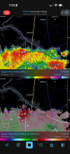
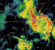
jefferson county remains undefeated since 2020.

Wasn't there one on 3/25/21?

I just now read over this thread, all of this went down during the last couple hours of my very busy work shift and it was so unexpected it didn't even occur to me to look for tornadoes happening today.
 

..OHIO


SOUTHWESTERLY MID-LEVEL FLOW WILL BE IN PLACE OVER THE OHIO VALLEY
AND LOWER GREAT LAKES TODAY. AT THE SURFACE, AN AXIS OF LOW-LEVEL
MOISTURE WILL BE LOCATED FROM EASTERN KENTUCKY INTO CENTRAL AND
NORTHERN OHIO, WHERE DEWPOINTS WILL BE IN THE MID TO UPPER 60S F. AS
INSTABILITY INCREASES DURING THE DAY, SCATTERED THUNDERSTORMS ARE
EXPECTED TO DEVELOP AND MOVE NORTHEASTWARD ACROSS THE INSTABILITY
CORRIDOR. RAP FORECAST SOUNDINGS IN CENTRAL OHIO AT 21Z HAVE 0-6 KM
SHEAR NEAR 30 KNOTS WITH 0-3 KM STORM-RELATIVE HELICITY AROUND 150
M2/S2. THIS COULD BE ENOUGH FOR AN ISOLATED TORNADO THREAT.
 
Cullman County storm in Holly Pond/Baileyton rated officially a EF-1 tornado by NWS. First official tornado to touch down in Cullman County since March 17, 2021.

Edit to correct my error - March 31, 2021, not March 17.
 
Last edited:
Tornado Warning Just north of Chattanooga.

Tornado Warning
National Weather Service Morristown TN
514 PM EDT Sun May 24 2026

The National Weather Service in Morristown has issued a

* Tornado Warning for... Central Hamilton County in east Tennessee...

* Until 600 PM EDT.

* At 514 PM EDT, a severe thunderstorm capable of producing a tornado was located over Walden, or 7 miles northwest of Chattanooga, moving northeast at 25 mph.
 

Attachments

  • Screenshot 2026-05-24 at 4.19.56 PM.png
    Screenshot 2026-05-24 at 4.19.56 PM.png
    579.9 KB · Views: 3
I am shocked that a tornado warning was in effect near my location, and my phone did not go off, nor was it posted on any of the Atlanta meteorologist's X feeds.
 
Back
Top