jiharris0220
Member
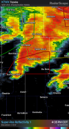
The LLJ right now is around 30knots, considering the storms are moving northeast at 35knots, they’re feeling even less shear than even that.
By the time the LLJ intensifies to the point that’s actually favorable for tornadogenises, these supercells will be upscale.
I held my tongue on this setup for a while, but this is exactly why cold front setups hardly ever produce significant tornado outbreaks, at all.
Never understood why the SPC issued a tornado driven moderate risk, let alone a PDS watch, when it was blatantly obvious for days that the cold front plus it’s parallel orientation with the deep layer wind shear vector would cause rapid upscale growth well before any appreciable intensification of the LLJ occurred for supercells to actually take advantage of kinematics.
Obviously it’s early, perhaps a favorable mesoscale interaction can manage to squeeze an sig tor, but I couldn’t help but shake my head seeing the “several strong tornadoes” likely tag knowing that it wouldn’t pan out.
But again, it’s still early, and these two supercells still have a limited window of at least 2 hours coinciding with a strengthening LLJ and baring any mesoscale interaction to produce sig tors.
But, at this point, it looks likely that this will now be the second moderate of the year that will feature only one or two weak tornadoes.
Other than the setup that produced the Enid twister and those two Dixie alley twin ef3s, every single one has been sh&t, and it’s been easy to tell before hand with every single one at least a day out. 2026 still on track to be the year of the b#st.