
WeathermanLeprechaun
Member
Semi-embedded QLCS will have potential to produce a brief tornado tmrw in E Central OK. Chances are higher if a cell can briefly get discrete given 20-30 kt LLJ in the area.
Follow along with the video below to see how to install our site as a web app on your home screen.
Note: This feature may not be available in some browsers.


YikesNot my favorite thing to see when I'm selling my house and no longer have reliable access to a garage. Wish there was more widely-available covered parking in the suburbs.
Good call, today dropped down to 2% non hatched.Today's setup in Oklahoma is tricky if you will. But I'm not exactly confident in much of a tornado risk today. Nowhere really interests me for today as a result. We will see.
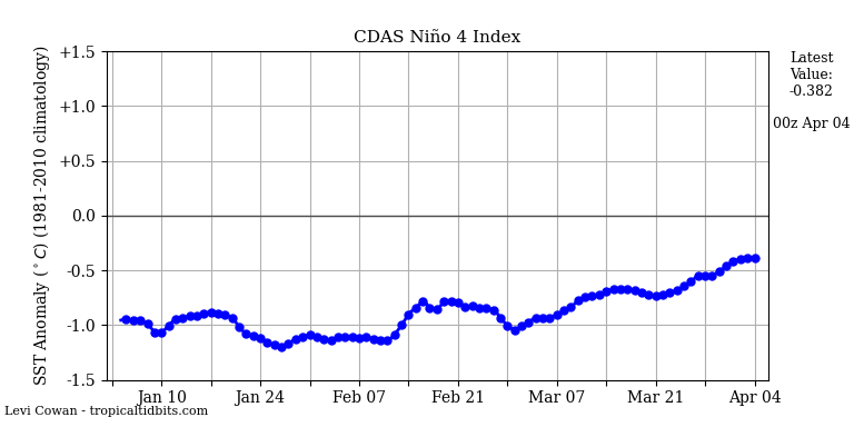
While there's not much of a correlation between El Nino and uptick tornadic activity, it simply can go either way. However, I do note that Fall severe weather seasons the last few years have been quite inactive (outside of notable events such as December 2021), so given that, I can see where this upcoming Fall breaks that trend.I’m quite interested to see how the second half of 2026 progresses in terms of tornadoes. 2025 was full force from March to June and then nothing much afterwards.
Is it possible that this year’s El Niño conditions lead to more tornadoes in the cold season?
I have been wondering if El Niño means an active fall/winter tornado season.While there's not much of a correlation between El Nino and uptick tornadic activity, it simply can go either way. However, I do note that Fall severe weather seasons the last few years have been quite inactive (outside of notable events such as December 2021), so given that, I can see where this upcoming Fall breaks that trend.
Dec 9th 2022 right?I
I have been wondering if El Niño means an active fall/winter tornado season.
Remember that Tennessee tornado outbreak a few December’s ago?