DISCUSSION...
...Sunday/Day 4 to Tuesday/Day 6...
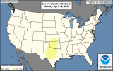
On Sunday, southwesterly mid-level flow will be in place across much of the nation. At the surface, a moist airmass will be located from the southern Plains north-northeastward into the Upper Midwest—much of the southern and central Plains, where some solutions have a subtle hortwave trough. Moderate deep-layer shear and steep lapse rates will favor supercells with large hail and severe wind gusts.
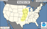
Mid-level flow is forecast to strengthen across the central U.S. on Monday. In response, moisture advection will continue in the Great Plains. By Monday afternoon, moderate instability should be in place from north Texas northward into the upper Mississippi Valley. Isolated to scattered thunderstorms are expected to develop across this airmass Monday afternoon and evening.
Moderate deep-layer shear and steep lapse rates will again be favorable for severe storms capable of large hail and severe wind gusts. A tornado threat may also develop.
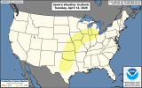
On Tuesday, an upper-level trough is forecast to move eastward into
The southern Rockies, as an associated mid-level jet streak, ejects northeastward across the southern High Plains. A moderately unstable airmass will likely be in place by afternoon from the southern Plains northeastward into mid to upper Mississippi Valley and the southern Great Lakes. Strong deep-layer shear is forecast over the southern and central Plains, where a substantial severe threat will be possible. Supercells with large hail, wind damage, and tornadoes are expected on Tuesday afternoon and evening. An upgrade will be possible across parts of the threat area once confidence in the timing of the ejecting trough increases.
...Wednesday/Day 7 and Thursday/Day 8...
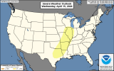
The upper-level trough is forecast to move eastward across the central U.S. on Wednesday, as a cold front advances southeastward through the Great Plains and Upper Midwest. Moderate instability is forecast to develop ahead of much of the front. Thunderstorms that form in areas sufficiently destabilized could pose a severe threat. The severe potential will likely continue into Thursday, as the front advances southeastward into the mid Mississippi Valley. However, model spread concerning the position of the front and timing of the trough increases substantially toward mid-week, suggesting a lot of uncertainty exists at this extended range in the period