• Welcome to TalkWeather!
    We see you lurking around TalkWeather! Take the extra step and join us today to view attachments, see less ads and maybe even join the discussion.
    CLICK TO JOIN TALKWEATHER

Tropical Storm Tropical Storm Florence

Tyler Penland

Mountain Snow Miser
Staff member
Moderator
Messages
254
Reaction score
154
Location
Blowing Rock, NC; Elevation 3,575ft
Looking good right now. Probably try to clear out an eye soon. Still moving due west or with a wobble either direction. Gonna be an interesting wait for the turn.
 

JayF

Technical Administrator
Staff member
Administrator
Moderator
Sustaining Member
Technical Admin
Messages
1,626
Reaction score
883
Location
Hartselle, al
HAM Callsign
KB4JCS
3C6B3D84-F9C3-4764-B2A0-43CF5D1E36BB.gif
 

rolltide_130

Member
Messages
828
Reaction score
378
Location
Harvest, Alabama
Special Affiliations
REALLY REALLY getting concerned about a stall near or after landfall. This will likely end up being a system with multiple hazards in the extreme range of seriousness.

I'm not trying to make this political, but I'm beginning to buy into the theory that climate change is having some sort of impact on so many storms stalling right at landfall or just inland. Its been a yearly issue since 2015 along the coast with both tropical and subtropical systems, and its something that hasn't been a regular occurrence previously.
 

warneagle

Member
Messages
3,788
Reaction score
3,381
Location
Arlington, VA
Special Affiliations
  1. SKYWARN® Volunteer
REALLY REALLY getting concerned about a stall near or after landfall. This will likely end up being a system with multiple hazards in the extreme range of seriousness.

We've had a ton of rain up here (I'm in the Maryland suburbs of DC) this year and it's been pouring all weekend. Almost any sustained rainfall in the mid-Atlantic is going to produce serious flooding problems in the DMV and PA
 

warneagle

Member
Messages
3,788
Reaction score
3,381
Location
Arlington, VA
Special Affiliations
  1. SKYWARN® Volunteer
Since I'm a historian, this is the kind of thing that fascinates me, and it really shows what a historical anomaly Florence's forecast path is.

(and no, the one that hit Florida isn't Andrew, it's an unnamed storm from 1901)

DmmoI1aW4AANnRr.jpg
 

Tyler Penland

Mountain Snow Miser
Staff member
Moderator
Messages
254
Reaction score
154
Location
Blowing Rock, NC; Elevation 3,575ft
Almost definitely a real eye clearing out now after trying all day. The bomb is about to go off.
 

warneagle

Member
Messages
3,788
Reaction score
3,381
Location
Arlington, VA
Special Affiliations
  1. SKYWARN® Volunteer
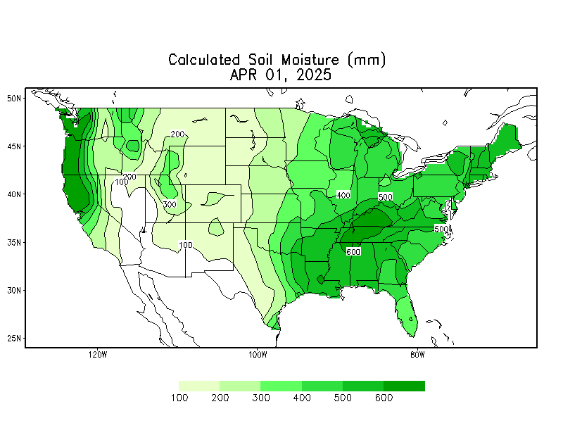
Yeah the current rainfall forecasts would result in some pretty catastrophic flooding up here. We're already way above average rain and the soil is very saturated. Plus more rain tonight and tomorrow. Even the low end of the rain forecasts could be very bad news.

EDIT: I checked some of the other maps and a substantial part of the mid-Atlantic (including here) is at the 99th percentile for soil moisture and a lot of the area is from 150% to as much as 300% of average YTD rainfall.

curr.w.full.daily.gif
 
Last edited:

Mike S

Administrator
Staff member
Administrator
Moderator
PerryW Project Supporter
Messages
2,005
Reaction score
1,152
Location
Meridianville, Al
Special Affiliations
  1. SKYWARN® Volunteer
Latest advisory is out. Florence up a bit to 90mph.

Looks like they've bumped the timeline up a few hours as well.
 

Attachments

  • 205027_5day_cone_no_line_and_wind_Florence.png
    205027_5day_cone_no_line_and_wind_Florence.png
    87.1 KB · Views: 0

rolltide_130

Member
Messages
828
Reaction score
378
Location
Harvest, Alabama
Special Affiliations
Latest advisory is out. Florence up a bit to 90mph.

Looks like they've bumped the timeline up a few hours as well.

Just based on satellite, I would argue its over 90. Its looking like something nasty is coming on IR with a very nice eye opening up.
 

KoD

Moderator
Staff member
Moderator
Sustaining Member
PerryW Project Supporter
Messages
1,380
Reaction score
697
Location
Huntsville, AL
ECMWF still more aggressive with it's landfall and inland hit projection. GFS maintaining a coastline stall & loop.
 

Daryl

Member
Messages
316
Reaction score
99
Location
Boaz,AL
NWS National Hurricane Center Miami FL AL062018
500 AM AST Mon Sep 10 2018

...FLORENCE RAPIDLY STRENGTHENING...
...EXPECTED TO BECOME A MAJOR HURRICANE VERY SOON...

SUMMARY OF 500 AM AST...0900 UTC...INFORMATION
----------------------------------------------
LOCATION...24.9N 58.9W
ABOUT 625 MI...1005 KM SE OF BERMUDA
ABOUT 535 MI...860 KM NNE OF THE NORTHERN LEEWARD ISLANDS
MAXIMUM SUSTAINED WINDS...105 MPH...165 KM/H
PRESENT MOVEMENT...WNW OR 285 DEGREES AT 9 MPH...15 KM/H
MINIMUM CENTRAL PRESSURE...969 MB...28.62 INCHES
 

Tyler Penland

Mountain Snow Miser
Staff member
Moderator
Messages
254
Reaction score
154
Location
Blowing Rock, NC; Elevation 3,575ft
How does Florence compare to Opal in regards to moving inland?
Not even close. Opal was booking. Florence may stall entirely or head into SW VA.

Sent from my SM-G960U using Tapatalk
 

Daryl

Member
Messages
316
Reaction score
99
Location
Boaz,AL
NWS National Hurricane Center Miami FL
1100 AM AST Mon Sep 10 2018

...FLORENCE RAPIDLY STRENGTHENS INTO A MAJOR HURRICANE...

SUMMARY OF 1100 AM AST...1500 UTC...INFORMATION
-----------------------------------------------
LOCATION...25.0N 60.0W
ABOUT 580 MI...935 KM SSE OF BERMUDA
ABOUT 1240 MI...2000 KM ESE OF CAPE FEAR NORTH CAROLINA
MAXIMUM SUSTAINED WINDS...115 MPH...185 KM/H
PRESENT MOVEMENT...W OR 280 DEGREES AT 13 MPH...20 KM/H
MINIMUM CENTRAL PRESSURE...962 MB...28.41 INCHES
 

rolltide_130

Member
Messages
828
Reaction score
378
Location
Harvest, Alabama
Special Affiliations
Florence is going nuts. 120 knot winds in the NE eyewall and 945 extrap pressue in the center on this pass.

This thing may be cat 4 before the day is over. This is insane.
 
Back
Top