
Argus
Member
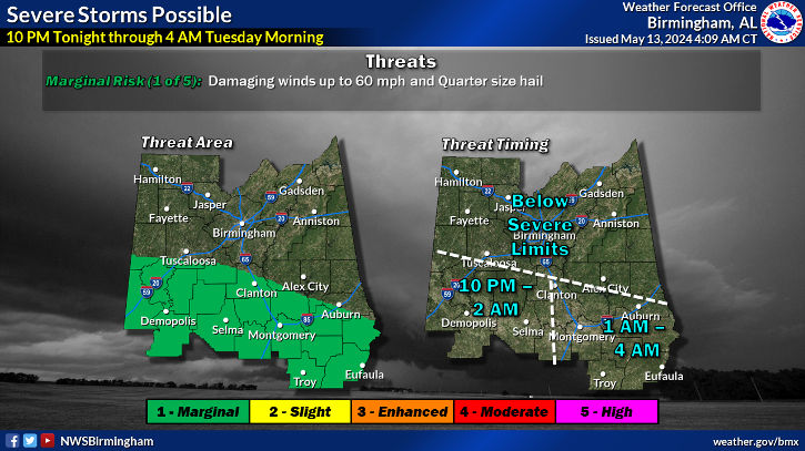
Meanwhile, according to the models, the threat increases for north Georgia including Athens.
Follow along with the video below to see how to install our site as a web app on your home screen.

Note: this_feature_currently_requires_accessing_site_using_safari
Maybe they will take us out of the watch. I have several people on standby to go in. I don't like that when there aren't even any storms approaching.Satellite trends are not encouraging for anyone hoping for storm development. Looks like the cap will hold. I'm fairly confident in saying the severe weather threat is now diminishing for North AL.
Maybe they will take us out of the watch. I have several people on standby to go in. I don't like that when there aren't even any storms approaching.
The storms in east-central Arkansas will be an issue for MS probably, but likely not AL.
Area Forecast Discussion
National Weather Service Huntsville AL
909 PM CDT Fri Jul 20 2018
.NEAR TERM...(Tonight)
Issued at 909 PM CDT Fri Jul 20 2018
The TN Valley is still playing the waiting game this evening.
Regional 00Z soundings and Univ. of Alabama-Huntsville soundings all
continue to indicate a highly unstable atmosphere. There is some
deep-layer shear in place but little low-level shear--at least for
now. Both UAH and BMX soundings show a very small cap around 800-825
mb, while the OHX sounding has it almost completely eroded. All that
is missing is some lift to erode this cap and realize the instability.
Severe convection so far has been limited to east Tennessee, but
convective initiation is occurring across Arkansas as of 02Z/9pm.
Convection-allowing models have been all over the place today. There
are signs that the 00Z CAM runs are beginning to get a better handle
on the situation but it is tough to put a lot of faith in them.
Several CAMs suggest explosive development over central/eastern
Arkansas, which then brushes NW Alabama in the 04-06Z timeframe. The
latest HRRR puts very little over the area for the entire overnight
period--but also is not resolving current upstream conditions very
well. So the 00Z CAM consensus is about the best available option
for right now. Instability is not a concern at this point, and deep-
layer shear should be fairly robust. Low-level shear will increase
over the next 2-4 hours as a low-level jet kicks into place around
the parent low, so the tornado watch seems reasonable for now.
0-1km SRH is on the rapid rise, but gotta break the cap to get anything going. Am thinking the threat looks more isolated rather than a widespread threat for our region now, at least if the HRRR continues to have a decent handle on things.
