• Welcome to TalkWeather!
    We see you lurking around TalkWeather! Take the extra step and join us today to view attachments, see less ads and maybe even join the discussion.
    CLICK TO JOIN TALKWEATHER

Archive March 18-20th, 2018 Severe Weather

Fred Gossage

Member
Meteorologist
PerryW Project Supporter
Messages
596
Reaction score
2,096
Location
Florence, AL
The GFS didn't even back the surface winds at all... even as close as the 18Z run yesterday, only a few hours out from "go time"...

sfcwind_mslp.us_se.png


It didn't until last night's 00Z run at 00hr (mid event), only because it was FORCED to by the observational data it was initialized with...

sfcwind_mslp.us_se.png
 
Messages
2,843
Reaction score
4,600
Location
Madison, WI
Surprised at the strength and longevity of the Ardmore tornado. Never really saw anything on radar to suggest that. If I'm not mistaken that was the state line cell which was more isolated from the cluster and I suspected it produced something at some point, but the velocities never looked that strong.
 

HazardousWx

Member
Messages
92
Reaction score
88
Location
Huntsville, AL
HAM Callsign
W4SSW
Special Affiliations
  1. SKYWARN® Volunteer
We had 2 warnings from that storm as it moved across the county. It was a good test for our automatic siren warning by polygon system. It did fine.
 

Taylor Campbell

Moderator
Moderator
PerryW Project Supporter
Messages
2,111
Reaction score
2,212
Location
Wedowee, AL
Special Affiliations
  1. SKYWARN® Volunteer
Surprised at the strength and longevity of the Ardmore tornado. Never really saw anything on radar to suggest that. If I'm not mistaken that was the state line cell which was more isolated from the cluster and I suspected it produced something at some point, but the velocities never looked that strong.

That storm would have been the best for chasing. It wouldn't have been so rain wrapped like the others, and the direction it moved east/northeast was better than the others that moved east/southeast. Chasing was fun yesterday, but it was one of the more dangerous setups for it.
 
Last edited:

rolltide_130

Member
Messages
828
Reaction score
378
Location
Harvest, Alabama
Special Affiliations
Surprised at the strength and longevity of the Ardmore tornado. Never really saw anything on radar to suggest that. If I'm not mistaken that was the state line cell which was more isolated from the cluster and I suspected it produced something at some point, but the velocities never looked that strong.

From a purely supercell structure on radar standpoint it was the storm of the day IMHO. It wasn't as HP as the line of embedded supercells to the south that would eventually produce the Jacksonville and Atlanta metro tornadoes, as well as numerous other ones.
 

HazardousWx

Member
Messages
92
Reaction score
88
Location
Huntsville, AL
HAM Callsign
W4SSW
Special Affiliations
  1. SKYWARN® Volunteer
From a purely supercell structure on radar standpoint it was the storm of the day IMHO. It wasn't as HP as the line of embedded supercells to the south that would eventually produce the Jacksonville and Atlanta metro tornadoes, as well as numerous other ones.
I watched video of it today. Cameras very close to it couldnt get a good image as it had so much rain. We did have debris flying toward the way the storm was coming from, we had a visible shift in the wind, and debris was blown in at least 3 different directions at the site of the hardware store.
 

rolltide_130

Member
Messages
828
Reaction score
378
Location
Harvest, Alabama
Special Affiliations
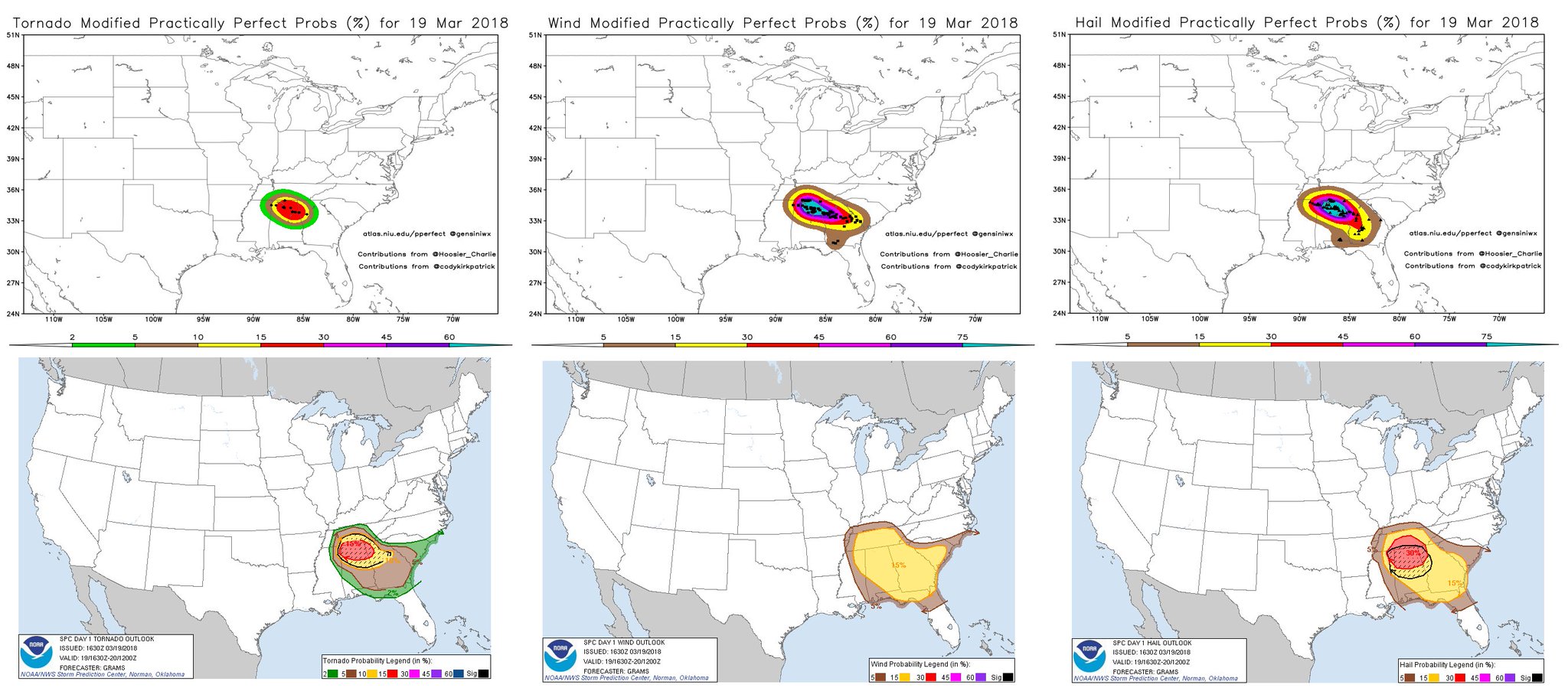
Victor Gensini's hindcast shows that SPC nailed the tornado risk and that we could have verified a high on wind reports alone..

As for hail, it was underdone but there's no high risk for hail.

DYxneT2W4AAaXrH.jpg:large
 

Mike S

Administrator
Staff member
Administrator
Moderator
PerryW Project Supporter
Messages
2,005
Reaction score
1,152
Location
Meridianville, Al
Special Affiliations
  1. SKYWARN® Volunteer
We had 2 warnings from that storm as it moved across the county. It was a good test for our automatic siren warning by polygon system. It did fine.

I was wondering why I never heard a siren last night. That's good to know.
 

Equus

Member
Messages
3,295
Reaction score
3,380
Location
Jasper, AL
Special Affiliations
  1. SKYWARN® Volunteer
Hail was obviously a bit underdone on the outlook, but am still pretty confused as to why they didn't at least bump the wind up to 30 or 30/hatched at some point. That's kind of odd for a higher end day. Also interesting seeing the graphics from BMX mentioning 70-80mph winds in a 15% unhatched SPC day. They could easily have bumped wind and hail dramatically higher and completely verified. I remember multiple MDT+ days back in 2008 or so where hail and wind were expected to be even less than today that were never lower than 45/hatched. But... the general public really probably doesn't care, leaving the weather community to debate these details. I gotta say though, it's pretty interesting to be talking about storms OVER-producing on an SPC outlook for once.

I can see where the calls of 'bust' come from, for those south of the hell-cluster; I dare say nearly half the tornado watch barely got more than a shower, here included. It's been noted that similarly large swaths of area on April 27 (also April 14, 2012, really) also saw virtually nothing - I was in the 45% TOR and only got two brief light showers in the evening round - due to the cellular nature, but in those large events that's expected, while in such a spatially concentrated event one would expect a larger area percentage to probably be affected.

Not to say the southern end of the MDT was a bad call at all though - had the cap not been so strong, we'd have definitely seen those showers south and west of the line explode and no one but the TV-obsessed moron whining about coverage of devastating tornadoes would be calling bust. As it stands though, we have an EF3, two EF2s I think, and a smattering of lower ones; I really think the outlook verified pretty well even in tornado probs despite a much different storm mode than expected and being very concentrated in that hell-cluster. At the very least, I feel we're going down in history as one of the state's most destructive hail days. There would be more to debate without the Jacksonville tornado, but now, I feel as though the outlook was quite close.
 

rolltide_130

Member
Messages
828
Reaction score
378
Location
Harvest, Alabama
Special Affiliations
The 15% hatched verified excellently by SPC standards. My personal forecast busted pertaining specifically to me really pushing the possibility of multiple significant to violent tornadoes traversing the TN Valley, but thankfully that didn't entirely verify. (I was particularly concerned that 2-3 semi-discrete to discrete supercells like what occurred near Ardmore would be traversing across the area and dropping long tracked, higher end tornadoes).

However, on the flip side, looking at the complex of HP cells today leaves me with the impression that those storms may be amongst the most impressive storm complexes in AL (Or even Dixie Alley..) history. A line of trailing, MASSIVE HP supercells with giant hail, extremely strong straight line winds, and embedded tornadoes (some strong) is something I'd expect during June in Nebraska and Iowa. (When we were launching soundings at SWIRLL, we could see the updraft of the storm from Huntsville and this was before they had even made it to the MS/AL state line).

Storms of this nature were rare for Dixie Alley and something that doesn't happen particularly often around here. This was very much NOT the typical Dixie Alley severe weather day by any stretch of the imagination, and this very much will be going down as a red letter day particularly in the portion of NE Alabama along and E of I-65.
 

Evan

Member
Messages
2,265
Reaction score
1,396
Location
McCalla, AL
Like the one with a nasty hook echo that's probably about to get a TOR?

Not trying to re-open a battle here, and I'm willing to discuss this fairly and professionally, so here goes...

1. buckeye05, would you still maintain that the moderate was a bust?

2. Do you believe the blobs we previously discussed the other evening, particularly the one Jacob referred to in this post, contradict the certainty of your statements from Monday evening?

I ask because I've seen a few people discuss their forecasts prior to the event, what they missed or hit on, and a more general discussion of the SPC's performance and WFOs.

Essentially, wondering if you still maintain your opinion from the other evening, or did later events provide a rationale to now draw a different conclusion. Have you discovered any particular variables that differed from some of the previous underproducing events that you've referenced recently? I certainly recall some of the events from the past 2-3 years in which things did play out as you had initially said, but have you noticed or uncovered anything as to why this ended differently (if you believe it ended differently from some of those underproducing events)?

Fred posted some recent info about the amount of forecast shear that was intriguing, and we also had the discussion about the direction of surface winds. Anything you've noticed as well?

Thanks.
 

buckeye05

Member
Messages
3,160
Reaction score
4,713
Location
Colorado
Not trying to re-open a battle here, and I'm willing to discuss this fairly and professionally, so here goes...

1. buckeye05, would you still maintain that the moderate was a bust?

2. Do you believe the blobs we previously discussed the other evening, particularly the one Jacob referred to in this post, contradict the certainty of your statements from Monday evening?

I ask because I've seen a few people discuss their forecasts prior to the event, what they missed or hit on, and a more general discussion of the SPC's performance and WFOs.

Essentially, wondering if you still maintain your opinion from the other evening, or did later events provide a rationale to now draw a different conclusion. Have you discovered any particular variables that differed from some of the previous underproducing events that you've referenced recently? I certainly recall some of the events from the past 2-3 years in which things did play out as you had initially said, but have you noticed or uncovered anything as to why this ended differently (if you believe it ended differently from some of those underproducing events)?

Fred posted some recent info about the amount of forecast shear that was intriguing, and we also had the discussion about the direction of surface winds. Anything you've noticed as well?

Thanks.
I don't want to drag this out either, but I'll at least answer.
No, this was not a bust, but it was an under-performer. I'd say there is a difference between those two things. This has been my opinion all along, I did not say the moderate was a bust at any point, and if you read through all my previous posts (if they aren't deleted), you'll see I used the word bust only once, to describe the 2017 events. The wording I used was "not reaching its ceiling of potential" or "unperformer". With the very real potential for multiple well organized, well spaced supercells capable of producing violent tornadoes as far south as the Bham metro not being realized yesterday, saying this event did not reach its ceiling is not inaccurate . So with that said, I stand by my original statements, but it did end up being a little nastier than I initially thought after the storm mode fully went to crap, so I'll give you that.

With the exception of Jacksonville, this reminded of one of the many 2017 Dixie events where the direction of the surface winds was possibly questionable, though it was not expected to put a major damper on the threat, yet ended up doing exactly that (though I realize other factors such as COD came into play with at least one 2017 bust). It should also be noted that despite the veered profile in Florida today, strong tornado potential was still mentioned in the discussion. No tornadoes were reported at all, and the event played out in a very similar manner to January 22, 2017, when a veered profile seems to have prevented a "cleaner" storm mode and low level rotation in an otherwise highly volatile environment. My take-away is that veering may not be the kiss of death in Dixie, but i'm not convinced it doesn't at least have some negative effect.
 
Last edited:
Messages
2,843
Reaction score
4,600
Location
Madison, WI
I'm curious, how close was the path of the Ashville-Ohatchee EF2 to that of the Shoal Creek/Ohatchee/Piedmont EF4 (next member of the same family as TCL-BHM) of April 27, 2011? That's another corridor that seems to get hit on a fairly regular basis (also notably on Palm Sunday 1994).
 

Fred Gossage

Member
Meteorologist
PerryW Project Supporter
Messages
596
Reaction score
2,096
Location
Florence, AL
I don't want to drag this out either, but I'll at least answer.
No, this was not a bust, but it was an under-performer. I'd say there is a difference between those two things. This has been my opinion all along, I did not say the moderate was a bust at any point, and if you read through all my previous posts (if they aren't deleted), you'll see I used the word bust only once, to describe the 2017 events. The wording I used was "not reaching its ceiling of potential" or "unperformer". With the very real potential for multiple well organized, well spaced supercells capable of producing violent tornadoes as far south as the Bham metro not being realized yesterday, saying this event did not reach its ceiling is not inaccurate . So with that said, I stand by my original statements, but it did end up being a little nastier than I initially thought after the storm mode fully went to crap, so I'll give you that.

With the exception of Jacksonville, this reminded of one of the many 2017 Dixie events where the direction of the surface winds was possibly questionable, though it was not expected to put a major damper on the threat, yet ended up doing exactly that (though I realize other factors such as COD came into play with at least one 2017 bust). It should also be noted that despite the veered profile in Florida today, strong tornado potential was still mentioned in the discussion. No tornadoes were reported at all, and the event played out in a very similar manner to January 22, 2017, when a veered profile seems to have prevented a "cleaner" storm mode and low level rotation in an otherwise highly volatile environment. My take-away is that veering may not be the kiss of death in Dixie, but i'm not convinced it doesn't at least have some negative effect.

The more I have looked at the "veered winds don't kill the threat" days here over the past few years, the more it looks like synoptically, that is true... but they need to be backed to at least 185-190 deg (or preferably more) on the smaller scale. The one CRITICAL thing we have learned is that we're going to have to be REALLY careful trusting how the models show the low-level winds in an event where you have a respectable surface low in place (even if it's not deepening with time, the 1974 surface low didn't deepen during the outbreak!)... and there are pressure falls in place across the warm sector. The low center does NOT have to be deepening with time in order for you to get pressure falls and an isallobaric response in the warm sector, as long as you somehow have pressure falls from the surface low and/or a pressure trough along a boundary approaching. All of the models have had a long-standing history of underdoing or even IGNORING the isallobaric responses related to low-level cyclones. Even before 4/27/11, this is what the NAM looked like with 0-1 km SRH less than two days before the event:

NAM_SRH_WRONG.png


The 18Z BMX sounding from that day, valid for the same time as the map above, had an 0-3 km SRH value of 842 m2/s2. Sure, the map above is 0-1 km... but we ALL know that the 0-1 km values had to be screaming high as well. That above only shows 0-1 km SRH values of 100 down to Jefferson / Shelby Counties that afternoon... and it verified 4-5 times higher, or more. The GFS itself even 6 to 9 hours out missed 0-1 km SRH at BMX Monday evening by as much as 500 m2/s2!!! That wasn't along the wedge boundary either, that was back further southwestward, in the free warm sector along the low-level jet axis.
 

champal3003

Member
Messages
69
Reaction score
24
Location
Anniston
Special Affiliations
  1. SKYWARN® Volunteer
I'm curious, how close was the path of the Ashville-Ohatchee EF2 to that of the Shoal Creek/Ohatchee/Piedmont EF4 (next member of the same family as TCL-BHM) of April 27, 2011? That's another corridor that seems to get hit on a fairly regular basis (also notably on Palm Sunday 1994).

Ashville-Jacksonville EF3 (upgraded late yesterday) path was only a few miles or less from the path of the EF4 that hit Shoal Creek-Piedmont. That corridor has seen several tornadoes through the years in which you can see here.......http://www.tornadohistoryproject.com/tornado/Alabama/Calhoun/map

This storm actually moved from NW to SE, in which most all others moved from SW to NE. You can use the map above in the link and zoom in and this storm moved from Southside down through AL hwy 204 through Jacksonville continuing across the mountain through Nances Creek across hwy 9.
 

Fred Gossage

Member
Meteorologist
PerryW Project Supporter
Messages
596
Reaction score
2,096
Location
Florence, AL
Ashville-Jacksonville EF3 (upgraded late yesterday) path was only a few miles or less from the path of the EF4 that hit Shoal Creek-Piedmont. That corridor has seen several tornadoes through the years in which you can see here.......http://www.tornadohistoryproject.com/tornado/Alabama/Calhoun/map

This storm actually moved from NW to SE, in which most all others moved from SW to NE. You can use the map above in the link and zoom in and this storm moved from Southside down through AL hwy 204 through Jacksonville continuing across the mountain through Nances Creek across hwy 9.
The Ashville to Ohatchee track is an EF2 that started from the same storm and lifted a touch west of where the Jacksonville EF3 started. They are separate tracks.
 
Messages
2,843
Reaction score
4,600
Location
Madison, WI
Did the other storm south of Ashville do anything? It had a fairly bright couplet for maybe 1 scan while the Jacksonville tornado was ongoing, then it slackened off.
 
Messages
2,843
Reaction score
4,600
Location
Madison, WI
The tornado list from this event is getting rather impressive (well worthy of a 15% hatched MDT). Goes to show you shouldn't consider an event an underachiever just because you don't see classic reflectivity structures, long-lived TDS's (at least not until Jacksonville) and live pictures of tornadoes. (I'm referring to myself here and not trying to call anyone else out, because I admit I had thrown in the towel on the day, closed out of GR Level 3 and the ABC 33/40 livestream and gone to do something else for awhile, and found the big TDS just past Jacksonville when I came back to do one last check before bed.)
 
Back
Top