• Welcome to TalkWeather!
    We see you lurking around TalkWeather! Take the extra step and join us today to view attachments, see less ads and maybe even join the discussion.
    CLICK TO JOIN TALKWEATHER

Severe WX April 12-15th, 2018 Severe Potential

Messages
179
Reaction score
59
Location
Adel, Ga
Ironically, I'll be visiting my mom on the gulf coast this weekend. Was also doing so during Tropical Storm Cindy. Might apparently be decently close to the action!
I'm staying just inland of the gulf this weekend also and notice that there isn't usually major tornado damage areas along the coast but rather minor damage from waterspouts moving ashore before they break apart. So in a risk area do they usually break apart from land interaction in the coastal towns and then reorganize into a more destructive storm later further inland?

Sent from my SM-G965U1 using Tapatalk
 
Messages
2,834
Reaction score
4,559
Location
Madison, WI
I'm staying just inland of the gulf this weekend also and notice that there isn't usually major tornado damage areas along the coast but rather minor damage from waterspouts moving ashore before they break apart. So in a risk area do they usually break apart from land interaction in the coastal towns and then reorganize into a more destructive storm later further inland?

Sent from my SM-G965U1 using Tapatalk

Land interaction wouldn't cause a severe thunderstorm/tornadic supercell not associated with a tropical cyclone to "break apart." Intense supercell tornadoes along the immediate Gulf coast are fairly unusual for other reasons, but the Pensacola area was hit twice by EF3s in February of 2016.
 

Kory

Member
Messages
4,928
Reaction score
2,119
Location
Tuscaloosa, Alabama
Land interaction wouldn't cause a severe thunderstorm/tornadic supercell not associated with a tropical cyclone to "break apart." Intense supercell tornadoes along the immediate Gulf coast are fairly unusual for other reasons, but the Pensacola area was hit twice by EF3s in February of 2016.
It's rare to get the dynamics down along the Gulf Coast that doesn't lead to an absolute mess precip wise. 2/23/16 and 2/7/17 were recent exceptions.
 

rolltide_130

Member
Messages
828
Reaction score
378
Location
Harvest, Alabama
Special Affiliations
It's rare to get the dynamics down along the Gulf Coast that doesn't lead to an absolute mess precip wise. 2/23/16 and 2/7/17 were recent exceptions.

For whatever reason it does seem like we're seeing those setups with increasing frequency along the coast.
 

Kory

Member
Messages
4,928
Reaction score
2,119
Location
Tuscaloosa, Alabama
For whatever reason it does seem like we're seeing those setups with increasing frequency along the coast.
It certainly does seem that way. Both of those events set records. 2/23/16 was the largest outbreak in KLIX’s CWA and 2/7/17 featured the strongest tornado in New Orleans history (EF3).
 
Messages
46
Reaction score
40
Location
Mountain in East, AL
Special Affiliations
  1. SKYWARN® Volunteer
BMX opts to stay with a slight risk for Saturday ATM

198d7981991b1ee29b13aa820d4bf6a6.jpg


Sent from my iPhone using Tapatalk
 

rolltide_130

Member
Messages
828
Reaction score
378
Location
Harvest, Alabama
Special Affiliations
It certainly does seem that way. Both of those events set records. 2/23/16 was the largest outbreak in KLIX’s CWA and 2/7/17 featured the strongest tornado in New Orleans history (EF3).

One theory I have is that the semi-permanent high amplitude base state we've been in the last several years is leading to more troughs digging further south towards the coast while shunting areas further north out more often.
 
Messages
587
Reaction score
411
Location
St. Catharines, Ontario
It certainly does seem that way. Both of those events set records. 2/23/16 was the largest outbreak in KLIX’s CWA and 2/7/17 featured the strongest tornado in New Orleans history (EF3).
2/23/16 was also (I think, although I might be wrong) the first outbreak to have several strong tornadoes at 30 degrees latitude or lower since 2008. There definitely does to be a trend towards more Gulf Coast outbreaks in recent years.
 

rolltide_130

Member
Messages
828
Reaction score
378
Location
Harvest, Alabama
Special Affiliations
Doesn't that create public confusion when SPC says Enhanced and the local office says Slight?

The office isn't obligated to follow the SPC risk if they disagree with it. I do know some very respected forecasters at BMX think that the threat level is too uncertain/conditional to follow SPC's lead so they have opted not to do so.
 
Messages
46
Reaction score
40
Location
Mountain in East, AL
Special Affiliations
  1. SKYWARN® Volunteer
Doesn't that create public confusion when SPC says Enhanced and the local office says Slight?
I would say those who do not follow weather like us and do not understand all the different agency's that are involved/coordination that goes into making a forecast... yes
 

rolltide_130

Member
Messages
828
Reaction score
378
Location
Harvest, Alabama
Special Affiliations
I would say those who do not follow weather like us and do not understand all the different agency's that are involved/coordination that goes into making a forecast... yes

Technically, SPC products are intended for a meteorological audience and the general public is supposed to rely on local WFOs. SPC just started getting really popular outside of the meteorological community when the media started showing their products on air.

And to be honest, I don't think it's that much different than when local media outlets are different. Brad Travis and Jason Simpson are both on the complete opposite ends of the spectrum regarding Saturday's threat for AL, and neither one has really backed off their wording much as of now.
 
Messages
46
Reaction score
40
Location
Mountain in East, AL
Special Affiliations
  1. SKYWARN® Volunteer
Technically, SPC products are intended for a meteorological audience and the general public is supposed to rely on local WFOs. SPC just started getting really popular outside of the meteorological community when the media started showing their products on air.

And to be honest, I don't think it's that much different than when local media outlets are different. Brad Travis and Jason Simpson are both on the complete opposite ends of the spectrum regarding Saturday's threat for AL, and neither one has really backed off their wording much as of now.

Agree for the most part but will say at least in out local DMA Mets weather on TV, blog or social media platforms reference the SPC outlook just about every time. Not sure if it is wise for those again that really do not even understand weather what they are even looking at to see different outlooks (edit I think BMX probably correct/more realistic for central AL). For most we have to remember the general public is often confused by the criteria and meanings of the products produced to begin with. Pretty much a visual/interactive society we see it we react differently vs being told what is happening.

Ok not to derail thread here...looking at the short term models would appear going to be boundaries lying around everywhere in the early afternoon. Always interesting to see these micro environments interact with the overall system itself. Also almost appears a meso low trying to appear towards the end of the run over eastern MS and central AL as well so lots to look at as dewpoints really begin to surge around the I-65 corridor late in the day. In the end agree like most the main threat is from the secondary QLCS line as it develops and grinds E at a snail's pace.
 

rolltide_130

Member
Messages
828
Reaction score
378
Location
Harvest, Alabama
Special Affiliations
Agree for the most part but will say at least in out local DMA Mets weather on TV, blog or social media platforms reference the SPC outlook just about every time. Not sure if it is wise for those again that really do not even understand weather what they are even looking at to see different outlooks (edit I think BMX probably correct/more realistic for central AL). For most we have to remember the general public is often confused by the criteria and meanings of the products produced to begin with. Pretty much a visual/interactive society we see it we react differently vs being told what is happening.

Ok not to derail thread here...looking at the short term models would appear going to be boundaries lying around everywhere in the early afternoon. Always interesting to see these micro environments interact with the overall system itself. Also almost appears a meso low trying to appear towards the end of the run over eastern MS and central AL as well so lots to look at as dewpoints really begin to surge around the I-65 corridor late in the day. In the end agree like most the main threat is from the secondary QLCS line as it develops and grinds E at a snail's pace.

I personally think SPC outlooks, unless they are modified to contain language that the average person can understand, shouldn't be used. If somebody just slaps a high risk on a map, most of the public has no idea what that means. Is high the worst it can get? What about enhanced? Where's enhanced at?

I got to tour WHNT with Christina Edwards last year, and one thing she told me is that you have to assume everyone you're talking to has the IQ of a 4th grader when you're a broadcast meteorologist. That really hit me hard in terms of how broadcast mets have to modify their products to fit an intended audience.
 

Brandon

Member
Messages
17
Reaction score
13
Location
Madison, AL
I personally think SPC outlooks, unless they are modified to contain language that the average person can understand, shouldn't be used. If somebody just slaps a high risk on a map, most of the public has no idea what that means. Is high the worst it can get? What about enhanced? Where's enhanced at?

I got to tour WHNT with Christina Edwards last year, and one thing she told me is that you have to assume everyone you're talking to has the IQ of a 4th grader when you're a broadcast meteorologist. That really hit me hard in terms of how broadcast mets have to modify their products to fit an intended audience.

A 4th grade IQ is being generous given the fact that most Alabamians can't even locate their home county on a map, per James Spann.
 

Taylor Campbell

Moderator
Moderator
PerryW Project Supporter
Messages
2,110
Reaction score
2,209
Location
Wedowee, AL
Special Affiliations
  1. SKYWARN® Volunteer
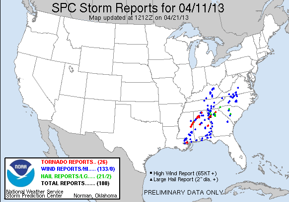
4/11/2013 still remains an analog, and the most interesting I think given the idea of pre-squall supercells indicated on the NAM, and EURO reflectivity products. There was a significant EF3 tornado that started as early as 11:33 am in MS, and tracked northeast for 56 miles. It was also a day that the forecast busted substantially with only a slight risk issued.

130411_rpts.gif.png
 

rolltide_130

Member
Messages
828
Reaction score
378
Location
Harvest, Alabama
Special Affiliations
4/11/2013 still remains an analog, and the most interesting I think given the idea of pre-squall supercells indicated on the NAM, and EURO reflectivity products. There was a significant EF3 tornado that started as early as 11:33 am in MS, and tracked northeast for 56 miles. It was also a day that the forecast busted substantially with only a slight risk issued.

130411_rpts.gif.png

Except for the one supercell, the slight risk verified rather fine. Also have to remember this was before the introduction of the ENH, and a hatched 10% would've been a slight.
 
Last edited:

warneagle

Member
Messages
3,788
Reaction score
3,381
Location
Arlington, VA
Special Affiliations
  1. SKYWARN® Volunteer
A 4th grade IQ is being generous given the fact that most Alabamians can't even locate their home county on a map, per James Spann.
That's hardly exclusive to Alabama, trust me.

It's even worse in Georgia, since (for weird historical reasons) we have 159 of them.

I guess I shouldn't be throwing stones since I couldn't label a county map of Maryland, but I can at least drop a pin on where I live.
 
Back
Top