• Welcome to TalkWeather!
    We see you lurking around TalkWeather! Take the extra step and join us today to view attachments, see less ads and maybe even join the discussion.
    CLICK TO JOIN TALKWEATHER

Severe WX April 12-15th, 2018 Severe Potential

MichelleH

Moderator
Moderator
Messages
888
Reaction score
1,288
Location
Cullman, AL
Oh yeah I don't mean any disrespect to him at all, especially with all the health struggles that have been running through his family recently. I just found it somewhat of an interesting forecast on his part.

Oh no, I didn't mean that. :) It's all good. Personally, I don't think any severe threat should be under-played because people are so complacent anyway, but that's just me. LOL
 

JayF

Technical Administrator
Staff member
Administrator
Moderator
Sustaining Member
Technical Admin
Messages
1,626
Reaction score
883
Location
Hartselle, al
HAM Callsign
KB4JCS
I think James Spann was tired this morning. He labeled this video April 11 2017.

 
  • Thread starter
  • Moderator
  • #83

KoD

Moderator
Staff member
Moderator
Sustaining Member
PerryW Project Supporter
Messages
1,380
Reaction score
697
Location
Huntsville, AL
I think James Spann was tired this morning. He labeled this video April 11 2017.


That's today's date. I think the producers name the video based on the recorded date and not the outlook period.
 

JayF

Technical Administrator
Staff member
Administrator
Moderator
Sustaining Member
Technical Admin
Messages
1,626
Reaction score
883
Location
Hartselle, al
HAM Callsign
KB4JCS
That's today's date. I think the producers name the video based on the recorded date and not the outlook period.
It's 2018 not 2017. I watch his videos daily.
 

Taylor Campbell

Moderator
Moderator
PerryW Project Supporter
Messages
2,109
Reaction score
2,203
Location
Wedowee, AL
Special Affiliations
  1. SKYWARN® Volunteer
4/11/13 is a pretty interesting analog in some regards.
 

Taylor Campbell

Moderator
Moderator
PerryW Project Supporter
Messages
2,109
Reaction score
2,203
Location
Wedowee, AL
Special Affiliations
  1. SKYWARN® Volunteer
If we keep this look on the NAM, and EURO I think we are looking at an enhanced risk on Saturday as well.
 

Richardjacks

Member
Meteorologist
Messages
1,161
Reaction score
1,331
Location
Atop Red Mountain Birmingham, Al
If we keep this look on the NAM, and EURO I think we are looking at an enhanced risk on Saturday as well.
i think you are right, especially for northern 2/3's of Miss, Al, and southern Tenn. Although the NAm looks little bit messy at times with location of new surface low and leftovers from qlcs...those need to be figured out.
 

amp1998

Member
Messages
59
Reaction score
45
Location
Alabama

ARCC

Member
Messages
503
Reaction score
309
Location
Coosa county
James Spann's assessment for this weekend I think is good. Jason Simpson however is saying the GFS has been more consistent than the Euro in terms of dynamic support? Not sure why he believes the GFS over the Euro for Saturday. Jason is also dead set on convection over the Gulf Coast on Saturday.

James Spann's assessment: https://www.alabamawx.com/?p=157821

Jason Simpson's assessment: http://whnt.com/2018/04/11/stormy-setup-getting-ready-for-a-wet-stormy-weekend/


To be honest, I don't see much difference between the Euro, NAM and GFS. The GFS is quickest and the NAM backs surface winds more, otherwise they look to be on the same page.
 

amp1998

Member
Messages
59
Reaction score
45
Location
Alabama
To be honest, I don't see much difference between the Euro, NAM and GFS. The GFS is quickest and the NAM backs surface winds more, otherwise they look to be on the same page.

EURO and the NAM are slower with the severe weather threat, which would bring a higher chance for severe storms on Saturday because it will give the atmosphere more time to destabilize and for the stronger dynamic support to catch up. The GFS would move everything into Alabama too soon potentially outrunning the better dynamic support and instability.
 

ARCC

Member
Messages
503
Reaction score
309
Location
Coosa county
EURO and the NAM are slower with the severe weather threat, which would bring a higher chance for severe storms on Saturday because it will give the atmosphere more time to destabilize and for the stronger dynamic support to catch up. The GFS would move everything into Alabama too soon potentially outrunning the better dynamic support and instability.

Not by much and it's really splitting hairs. The Euro is slower, but cape wise it's about the same as the GFS. The Euro has max capes before the squall line around 600-1000, the GFS about the same but about twelve hours faster and to no surprise the NAM is most bullish with 1000-1750 over a larger area.

Upper level wise they all are close except the GFS being faster with the whole system.
 

Kory

Member
Messages
4,928
Reaction score
2,119
Location
Tuscaloosa, Alabama
It's when that second vort max rounds the base of the initial occluded trough and the whole thing goes negative tilt, we'll see a secondary low pressure form. That will serve to really back the winds and ramp up the LLJ later Saturday. With the height falls associated with it, I wouldn't rule out some convection ahead of the main QLCS, which will probably be pretty rough.

Also of note, it appears the QLCS will slow down as it exits MS and enters AL as the whole trough is transitioning to a negative tilt. Probably a decent flooding threat as well where ever it slows down because these PWATs are 2-3 sigmas above normal.
 

champal3003

Member
Messages
69
Reaction score
24
Location
Anniston
Special Affiliations
  1. SKYWARN® Volunteer
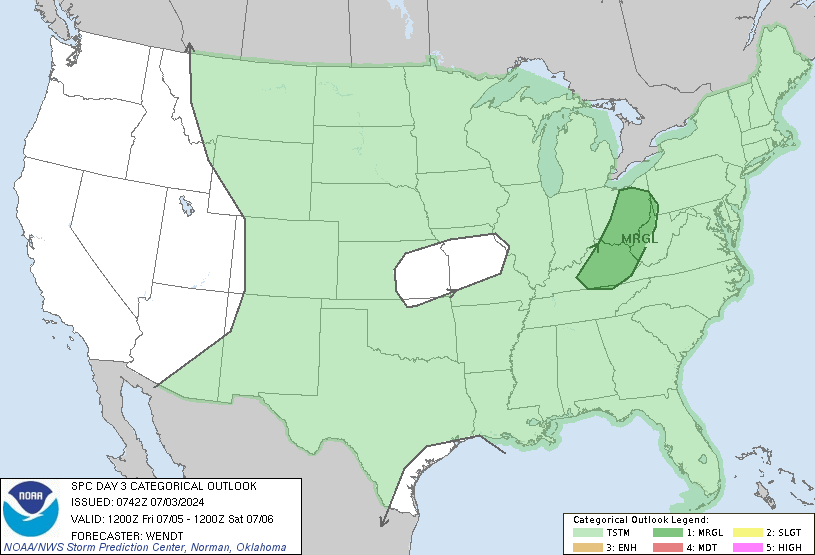
Enhanced Risk now out for Saturday.
day3otlk_0730.gif
 
Messages
46
Reaction score
40
Location
Mountain in East, AL
Special Affiliations
  1. SKYWARN® Volunteer
Enhanced Risk now out for Saturday.
day3otlk_0730.gif

For a day 3 pretty impressive

From SPC

..Mid South/Tennessee Valley into the central Gulf Coast states...
Widespread showers and thunderstorms are forecast to be ongoing over
western fringes of the outlook area Saturday morning. The
associated cloud cover casts some uncertainty with respect to degree
of warm-sector destabilization which will be possible downstream.
Greatest CAPE will likely evolve from central Alabama south to the
central Gulf Coast, as southwest flow aloft should carry thicker
cloud debris across the Tennessee Valley region.

As the airmass destabilizes, expect reintensification of storms
near/ahead of the advancing front, with organization aided by strong
low- to mid-level flow likely to exceed 50 to 60 kt in the 850 to
500 mb layer over portions of the Alabama vicinity by late
afternoon. While somewhat unidirectional/southerly flow should
limit low-level shear to some degree, and roughly front-parallel
flow and linear frontal forcing suggests linear storm mode, damaging
winds can be expected with passage of the frontal storm band. Hail
-- and a tornado or two -- will also be possible, particularly with
southward extent. A gradual decrease in storm intensity/severe risk
should commence later in the evening, as convection reaches the
southern Appalachians and Florida Panhandle.


Sent from my iPhone using Tapatalk
 

ARCC

Member
Messages
503
Reaction score
309
Location
Coosa county
One area to watch is right on the gulf coast. All models show the expected max in instability right there along with strong upper level divergence. These areas normally get nailed in these high amplitude neutral/negative tilt setups where messy storm mode doesn't matter as much due to the unhindered gulf moisture.
 

Kory

Member
Messages
4,928
Reaction score
2,119
Location
Tuscaloosa, Alabama
Outflow from the initial push of the QLCS will be key too. How far east does it make it before the second wave? That could clamp down on the threat for the Northern and Western portions of AL as indicated by some mesoscale guidance. Still quite far out for models to resolve this.
 

rolltide_130

Member
Messages
828
Reaction score
378
Location
Harvest, Alabama
Special Affiliations
Starting to get a 4/15/11 feel from this system. The NAM is starting to shunt North AL out of the warm sector while setting the stage for a potential significant tornado outbreak further south.
 

Equus

Member
Messages
3,295
Reaction score
3,380
Location
Jasper, AL
Special Affiliations
  1. SKYWARN® Volunteer
Ironically, I'll be visiting my mom on the gulf coast this weekend. Was also doing so during Tropical Storm Cindy. Might apparently be decently close to the action!
 

Fred Gossage

Member
Meteorologist
PerryW Project Supporter
Messages
596
Reaction score
2,096
Location
Florence, AL
Starting to get a 4/15/11 feel from this system. The NAM is starting to shunt North AL out of the warm sector while setting the stage for a potential significant tornado outbreak further south.

I'm not so sure the storm mode would cooperate this time for something like that, but in terms of placement and the overall evolution of how the threat areas evolve, I'm starting to think this idea is 100% right. ALL of the CAMs are bringing the line into northwest Alabama before sunrise on Saturday, and while we shouldn't get too hung up on convective models and the exact evolution they depict, they do a much better job at handling cold pool propagation than models like the 12 km NAM or the Euro... which may STILL be right with the synoptic evolution, while the GFS might be the synoptic model that's right with the timing of the convection and actual impacts, but for the wrong reasons.
 
Logo 468x120
Back
Top