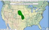
Sunday
Tomorrow is conditional for storms to initiate but areas of the Dakotas and E KS/W MO, maybe extending down into SW MO. I do believe with higher instability around SW MO, storm initiation is a good likelihood for isolated svr. Damaging winds and large hail will be the main threat with fairly meager 30-40 kt flow in the region. After 03z, when the main belt of flow arrives and into 06z-09z, isolated significant svr is possible in SW IA/W MO with a couple discrete, elevated storms capable of damaging winds and hail. Tornado threat is very nonzero tmrw.
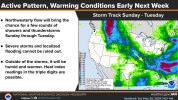
MONDAY.
A localised belt of flow should shift its way SE, bringing with it 50+ kt of flow into the W TN area. For June, this is slightly anomalous. However, thankfully, this miniature shortwave trough and the amount of spatial area that 50+ kt area covers is low. Why do I say this? Well, with fairly large and expansive instability, this seems like a ripe significant damaging wind day for Dixie Alley, in particularly, the Memphis area. If you got a MCS in that bit of flow, you'd be talking quite the event.
While storms do develop in weaker belt of flow, 25-35 kts, the environment for damaging wind is impressive. Nearly 4k SBCAPE, and DCAPE approaching 1.4k. Even supercells in this environment may produce significant damaging winds upward to 70-85 mph, with downbursts being possible in NE AR. The question right now is do we grow upscale? I've noticed many events supposed to be a long line with significant swaths of damaging winds this year have all remained discrete and not utilised that potential. Even today to some extent in the Enhanced wasn't a full blown line. So right now, imo, a conditionally significant MCS event is on tap with this SE flow as it stands. Expecting Monday to be a slight/enhanced risk perhaps for damaging winds sometime soon, it certainly may be a big time day for damaging wind and not the swirly we usually see in the Mid South-Dixie.
TUESDAY
A trough will move into the northern Plains, bringing with it 50-60 kts of flow. But, storms will tend to stay out of this more robust shear aloft from SE Montana to the Canada border. Storm initiation seems decently likely in the NW South Dakota vicinity where weaker flow of 30-40 kts is expected. Regardless, severe convection with perhaps a all hazards threat may exist.
Apologies if this was a bit more broad in nature, I'll have a better discussion up tomorrow on these days as a result but it's nearly 4am here. Sleepy.