
Tog southwest of Hattiesburg ms
Navigation
Install the app
How to install the app on iOS
Follow along with the video below to see how to install our site as a web app on your home screen.
Note: This feature may not be available in some browsers.
More options
-
Welcome to TalkWeather! We see you lurking around TalkWeather! Take the extra step and join us today to view attachments, see less ads and maybe even join the discussion. CLICK TO JOIN TALKWEATHER
You are using an out of date browser. It may not display this or other websites correctly.
You should upgrade or use an alternative browser.
You should upgrade or use an alternative browser.
5/5-5-6 2026 severe threat
- Thread starter Justin Hindman
- Start date
DanLarsen34
Member
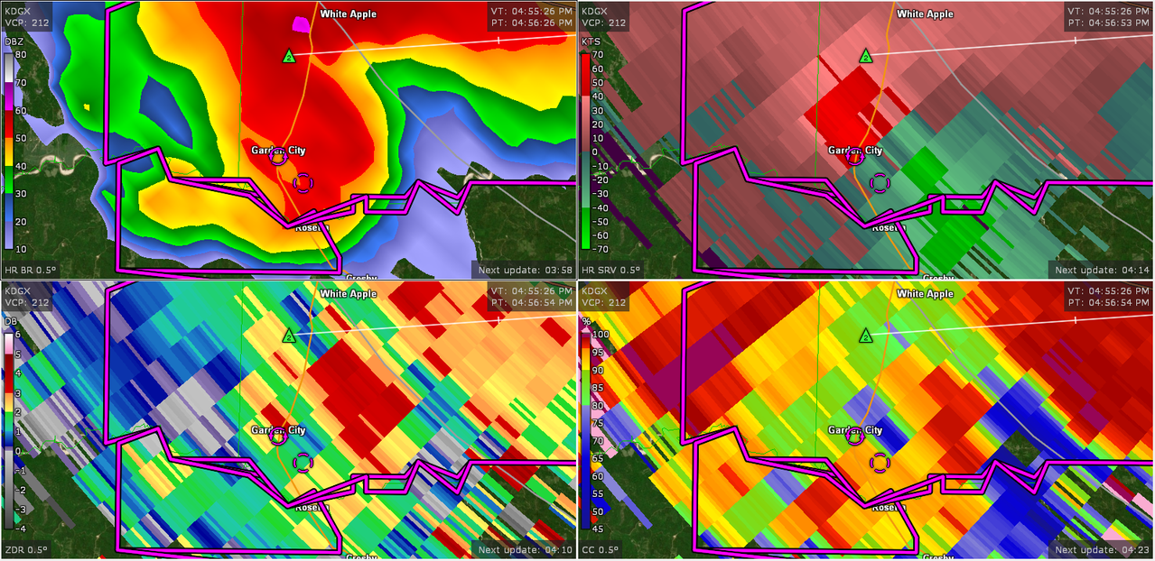
Debris to 15,000 feet now, Jesus. This should go TE shortly unless something changes.
It’s basically reached tornado emergency criteria now with both CC drop, TDS height, and velocity couplet. I think we’ll see it as it gets closer to Bude.
TornadoFan
Member
TOG southwest of Hattiesburg now!
Kds86z
Member
Tornado Otg by Hattiesburg as well.
Dude that pds tornado is venting out that debris. That is a violent tornado.
Violent tornado there in SW MS. Just had a VROT in excess of 95 kts from KDGX and that's way up there. TDS is getting over 20k feet.
DanLarsen34
Member
It’s basically reached tornado emergency criteria now with both CC drop, TDS height, and velocity couplet. I think we’ll see it as it gets closer to Bude.
There’s also a small debris ball now that’s visible on reflectivity.
warneagle
Member
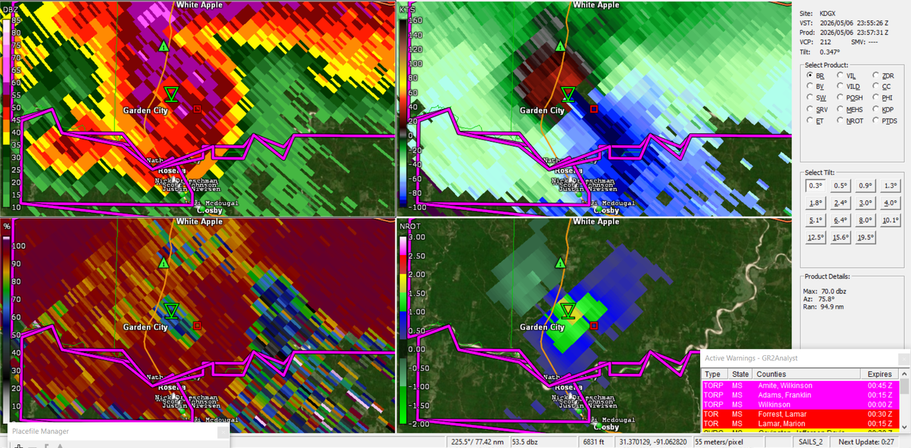
TORR moving into the Hattiesburg area
TH2002
Member
- Messages
- 4,974
- Reaction score
- 11,116
- Location
- California, United States
- Special Affiliations
- SKYWARN® Volunteer
I just realized that I STILL haven't upgraded GRLevel3 2.93 to 3.00, which means I don't have access to the KHDC radar...
Regardless, KDGX is also picking up the debris ball on the Garden City tornado. Very bad situation.
Regardless, KDGX is also picking up the debris ball on the Garden City tornado. Very bad situation.
cincywx
Member
That TDS on the SW MS cell grew substantially after moving through Garden City.
Idk what it just hit but that TDS just got way bigger and deeper.
Spotter Network shows our very own @Taylor Campbell located in Purvis, likely in the storm's path. I hope he stays safe!Another very strong and tight velocity couplet just to the East.
Tornado emergency!
TornadoFan
Member
Tornado emergency issued on the SW Mississippi tornado!
Ozonelayer
Member
TOR-E!
DanLarsen34
Member
Tornado emergency just got issued for Bude and Meadville. The CC drop is absolutely disgusting right now as well. This is a very high-end tornado
jiharris0220
Member
The jet streak speed and its orthogonal orientation to the PBL plus the stouter than expected 700mb inversion layer and surface mixing has allowed for a far more discrete storm mode than expected from most cams. The hrrr began to notice around a day ago, it also trended stronger in helicity streaks.
The main failure mode for today are the meager LLLR and extremely low LFC, but again, the higher than expected mixing ratios has elevated the LFC at a high enough level to actually allow air parcels to gain enough acceleration to beef up the updrafts of the OWS supercells.
Notice how the cloud tops in the last hour spiked to -70c coinciding with the rapid increase in LLJ velocity, and soon enough wallah, you have multiple strong tornadoes on the ground.
kcyalater
Member
there is literally nothing to stop the two S MS supercells from dropping long trackers.