tennessee storm chaser
Member
- Messages
- 1,877
- Reaction score
- 4,288
- Location
- jackson tennessee
- Special Affiliations
- SKYWARN® Volunteer
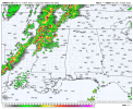
TimeThe line is convecting All the way into Arkansas and Oklahoma.
Now let’s see what can get out ahead that soon
Follow along with the video below to see how to install our site as a web app on your home screen.
Note: This feature may not be available in some browsers.
TimeThe line is convecting All the way into Arkansas and Oklahoma.
Is that right? No warnings for 5 years? That seems impossiblei think birmingham, AL lucky streak of 5 years with no tornado warnings is in jeopardy tonight

Shows up on a number of models, so that would be interesting if it comes true.

I think all of N GA should be in the enhanced risk?All I can say is: NO. Just NO!
View attachment 51865
This severe weather thread specifically has to do with severe storms and tornadoes. Like Michelle said, because of how busy this event is expected to be THE MODERATORS are saying to move discussions about the fire to that thread.The wild fires are part of today’s threat though.


The ENH risk is wind driven, but we will see what the SPC says at 4p ET.I think all of N GA should be in the enhanced risk?
That last picture in the bottom right had discrete cells directly to my SW. I am REALLY WONDERING if they are going to make it to me before the line, or if they will merge with it???Pretty clear uptrend on HRRR guidance for tonight. Not take-it-to-the-bank levels of confidence, but it's picking up on 1) embedded QLCS rotations, with at least conditional sigtor potential, and 2) some possible stuff out ahead of it, which will likely mingle with the line itself, which could lead to nudgers that enhance QLCS sigtor potential.
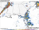
View attachment 51868View attachment 51869View attachment 51871View attachment 51872


Not so sure about the strong tornado threat this afternoon across the mid-MSV, but across the lower MSV into the Southeast late tonight is a different story, and with ample WAA and strong forcing, I'm not concerned about cloud cover and diurnal warming at that point.I'm not really buying into the tornado threat today at all, but a very big thing to note is all the CAMs were showing 100% cloud coverage from sun up to sundown today. For example, here is yesterday's 12z HRRR forecast for right now. Compare that to current satellite imagery and it's a much different story. If trends continue, i'll be a lot more bullish about today.
View attachment 51875
View attachment 51874
i was wrong.Is that right? No warnings for 5 years? That seems impossible

 www.wvtm13.com
Shows up on a number of models, so that would be interesting if it comes true.
View attachment 51867