
I agree with @Clancy. The only thing not locked in is main type of precipitation. Otherwise, we're locked in at this point for a major winter storm
Navigation
Install the app
How to install the app on iOS
Follow along with the video below to see how to install our site as a web app on your home screen.
Note: This feature may not be available in some browsers.
More options
-
Welcome to TalkWeather! We see you lurking around TalkWeather! Take the extra step and join us today to view attachments, see less ads and maybe even join the discussion. CLICK TO JOIN TALKWEATHER
You are using an out of date browser. It may not display this or other websites correctly.
You should upgrade or use an alternative browser.
You should upgrade or use an alternative browser.
January 23-25th Winter Wx
- Thread starter UncleJuJu98
- Start date
Well I guess it's time to finally winterize the pool...
Given the lack of snow removal infrastructure in these areas, this mess is gonna persist well into Monday
Given the consistently low temperatures following the event, if something doesn't change significantly, I think things will remain hectic until Thursday or Friday next week easily. This would be a huge event even up here in the Midwest, down South it's basically unprecedented. It's not like Northern states can just send plows to mop it up quickly either, because snow and ice is covering such a large area from Dallas to Charleston.
Gail
Member
We normally get power back on super fast here in town since all the services are within a block of where I live (Monroe County EPA is awesome), but I am worried we may be out for days with this one.I agree with @Clancy. The only thing not locked in is main type of precipitation. Otherwise, we're locked in at this point for a major winter storm

Ars4ua
Member
What would need to happen to prevent the warm nose ?
Ars4ua
Member
Me too. Models usually don’t handle these wellIm really curious to how strong this CAD wedge will be.
- Messages
- 751
- Reaction score
- 2,465
- Location
- Mississippi State University
- Special Affiliations
- SKYWARN® Volunteer
Is CAD short for Cold Air Dam?
- Moderator
- #188
YesIs CAD short for Cold Air Dam?
sak
Member
IDK how relevant this really is, but interesting to note... The EPO (Eastern Pacific Oscillation) hit -381 on January 18th. Best I can tell, that's the lowest it has been since January 26th, 1991. This metric tends to correlate with steering brutally cold arctic air into the lower 48.
For reference, before the March 12/13, 1993 blizzard, the values were in the -250 to -300 range on March 10 to March 13th and Birmingham dropped to 2 degrees on March 14th.
https://downloads.psl.noaa.gov/Public/map/teleconnections/epo.reanalysis.t10trunc.1948-present.txt
For reference, before the March 12/13, 1993 blizzard, the values were in the -250 to -300 range on March 10 to March 13th and Birmingham dropped to 2 degrees on March 14th.
https://downloads.psl.noaa.gov/Public/map/teleconnections/epo.reanalysis.t10trunc.1948-present.txt
Cyclonic Paracosm
Member

Oh thats not good at all several hours ago I was in like a 40% now its a 70 I think the red shades are weird
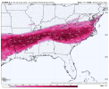
I don't know what the Euro AI Ensemble is smoking, but I like it. Has 30% to 70% probabilities of seeing equal to or greater than 12 inches of snow for North MS and 20% probability of seeing equal to or greater than 18 inches. LOL!
Attachments
akt1985
Member
There is now an Extreme Cold Watch in effect for parts of Minnesota and Wisconsin.
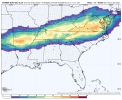
18z Euro just decided everyone gets in on the fun. Holy crap. I don't remember ever seeing such a widespread high impact snow event. Everything in purple is 6+ inches.

I don't know what the Euro AI Ensemble is smoking, but I like it. Has 30% to 70% probabilities of seeing equal to or greater than 12 inches of snow for North MS and 20% probability of seeing equal to or greater than 18 inches. LOL!
Generational Euro crack run.
Equus
Member


GFS needs to settle down
That GIF fits perfectly! LOL!
Atomz
Member
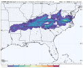
Could someone post the 18z Euro ice totals for the SE?
Ars4ua
Member
Help explain this for me ?
Atomz
Member
Euro is hellbent on giving ATL a monster ice storm, lmao.Here you go
Honestly, with how consistent these ice teens have been, I wouldn’t be surprised if we were under a watch by tomorrow afternoon.