• Welcome to TalkWeather!
    We see you lurking around TalkWeather! Take the extra step and join us today to view attachments, see less ads and maybe even join the discussion.
    CLICK TO JOIN TALKWEATHER

Severe WX Severe Weather Threat 3/14-3/16

All that being said, I want to go on record and say, based on current variables, and the last several winter storms we've seen, I predict storms will fire up early and intensify rapidly, and Mississippi will get hit the hardest. It has all the strongest ingredients and I don't think that atmosphere will wait around very long to start popping off. Both Humidity and dew points will rise earlier and faster than projected currently.
 
I've been doing some research and I think synoptically there really isn't a similar setup to this upcoming system with the strong, compact shortwave racing through on Friday followed by a broad, longwave trough following closely behind the following day. However, I was able to draw comparisons between the trough evolution for Friday's event and the trough evolution for the 12/15/21 derecho/tornado outbreak. The following screenshots are the 12/15/21 system at 21z and at 18z on the most recent GFS:
Screenshot 2025-03-12 004444.pngScreenshot 2025-03-12 004524.png

Friday's trough is notably more negatively tilted and is a closed wave. Additionally, the LLJ on Friday is weaker than 12/15/21 but has slightly more CAPE to work with. As such I think Friday's event is potentially being overlooked. Despite the moisture issues present on the models, there is still 1000-1500j/kg CAPE across NW MO, E IA, and W IL for the system to work with and the models show convection in those areas. It is a sensitive setup as less moisture than modeled would result in a weaker event, but even slightly more moisture than modeled and the possible ceiling gets raised. It's a low floor/moderate-high ceiling setup imo.

With regards to Saturday, it 100% looks like the bigger day, and I wasn't able to find a similar analog with this preceding wave. It seems that most other longwave trough events are essentially the only show in town. I don't think we'll know for sure until we get closer. Obviously, MS/AL/TN/GA is the main threat area, but I wouldn't count out the KY/IN/OH area either as a few models are bringing 60s dews up to the Ohio River.
 
I think those 3 states you mentioned in the Ohio Valley Region will definitely see severe storms. Moisture looks to be the primary issue the further North you go (no surprise). I know 500mb winds will be HOWLING, will that cause the storms to stretch apart too quick and just end up as a rainy windy mess?
 
If the Euro is indeed incorrectly over-convecting on itself (and I think it is with a plume of 8-8.5 lapse rates in the morning but little to no cap, it's unrealistic), you very likely won't see it trending toward fixing it. When it does this, it never does, even 00-06 hr. However, we're seeing an appreciable number of Euro ensemble members not buying into the BS. Some members do a similar thing, as you'd naturally expect with them running off the framework and parameterizations. But with several members not buying into it, that tells me a lot. It will take until we get into CAM range to let the higher-resolution data confirm our suspicions about the Euro and it's convective evolution, but this tells me a good deal.

1741763022528.png 1741763052178.png 1741763083654.png 1741763116953.png
 

Attachments

  • IMG_7210.jpeg
    IMG_7210.jpeg
    171.7 KB · Views: 0
  • IMG_7211.jpeg
    IMG_7211.jpeg
    196.5 KB · Views: 0
New SPC Day 3 is hot off the press. Hopefully I added correctly

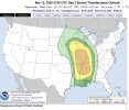
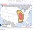
That is one hell of a large 30percen hatched area for day 3 I ever seen…. Mentions supercells with large strong tornadoes over the mid south region… almost a upgrade is guaranteed coming
 
The cam models are getting into range now, here’s a sounding from the NAM model taken in South-central Mississippi 1pm Saturday.

The NAM also shows a rather broad latitudinal orientated parameter space, gives plenty of room for any possible OWS convention to actually make use of the volatile kinematics.

Seemingly a completely different story from Mar 3-5th recently, important to keep in mind this is still days away and the forecast can change drastically for better or worse.
1741769437956.png1741770146423.png
 
Last edited:
1741769644946.png

Day 4-8 Convective Outlook
NWS Storm Prediction Center Norman OK
0345 AM CDT Wed Mar 12 2025

Valid 151200Z - 201200Z

...SEVERE WEATHER OUTBREAK POSSIBLE ON D4/SAT...

...DISCUSSION...
...Day 4/Sat - Central Gulf Coast States to the Ohio Valley...

A strong large-scale upper trough is forecast to quickly move across the Plains to the MS Valley on Saturday. An intense jet streak will move across the Deep South into the OH Valley as this occurs. At the surface, a low secondary to the 980 mb low over the Upper Midwest is forecast to develop during the late morning/early afternoon across the mid-South. This will aid in further northward transport of rich Gulf moisture into portions of the Lower MS Valley and TN Valleys.
Atop this moisture-primed boundary layer, cold 500 mb temperatures are forecast. This may support fairly steep lapse rates, which would foster moderate instability across portions of MS/AL amid supercell wind profiles. However, some uncertainty remains tied to the evolution of convection in the Day 3/Fri period into the morning hours of Saturday. Some forecast guidance suggests a relatively pristine warm sector will be maintained, or if only isolated
convection develops overnight/early Saturday, recovery could occur.

If this scenario unfolds, a concerning severe weather setup supporting all-hazard severe could unfold across portions of LA/MS/AL through the day and into evening, and eventually spreading
east into GA overnight.
Trends will be monitored closely over the coming days and further adjustments to the 30 percent/Enhanced risk
area may be needed in future outlooks.


With northward extent, instability will become more limited. Nevertheless, sufficient moisture amid intense deep-layer flow will support swaths of strong/damaging winds into the Ohio Valley and portions of the central Appalachians Saturday and Saturday night. Higher outlook probabilities may be needed in subsequent outlooks if confidence increases.

...Day 5/Sun - North Florida into the Carolinas and Mid-Atlantic...
A strong upper trough will shift east across the Midwest and Southeast on Sunday. Strong deep-layer southwesterly flow ahead of the trough will overspread much of the eastern U.S. atop a moist
boundary layer. Bands of convection will likely produce swaths of strong to severe gusts ahead of an eastward-advancing cold front.

...Days 6-8/Mon-Wed...
An upper trough will move offshore over the Atlantic on Monday, while a broad upper ridge spreads across the Plains in its wake. Another large-scale upper trough will move across the western U.S. on Tuesday, ejecting across the Plains and into the MS Valley on Wednesday. Some severe potential could return to parts of the
central or south-central states toward the end of the period with this system, but current model forecasts suggest moisture return in the wake of the Day 4/5 system will remain poor. Trends will be monitored over the coming days.

..Leitman.. 03/12/2025
 
Last edited:
The cam models are getting into range now, here’s a sounding from the NAM model taken in South-central Mississippi 6am Saturday.
View attachment 35132
oh no..... this one legitimately makes me feel sick. I really hope that doesn't verify.

Edit:
If that sounding verifies we will have some incredibly violent tornadoes on our hands Saturday. The SPC clearly isn't pulling any punches either. It's time to start ringing the alarm bells. This is shaping up to potentially be the worst outbreak of the last decade+ if we keep trending in this direction.
 
Last edited:
I hope my comment this afternoon wasn't interpreted as drawing similarities between this system and 04/27/2011. The SRH was 600+ m2/s2 in 2011. We aren't touching that currently. Considering it's the variable which fuels rotation, i'd say that's a pretty major difference between the two. Although CAPE is equally high in this system, it isn't nearly as widespread as and abundant as 2011. If 2500 CAPE is high octane gasoline, 2011 had a full tank, and 2025 has a half tank.

Once again, I'm unqualified to draw comparisons, but if I contributed to the hype we were seeing earlier, I want to equally contribute to the level headed reasoning we need now.
1741773407802.png
i think this will help with the whole is it enough for a superoutbreak or not

only 2 events came close of having what was on the far right side of this. but here are some problems with these 2 events.
1:Greenfiled Tornado event: LCL was at 0.903 km and SCP was at 27.5 (area wasn't super wide)
2: May 20 2019 Forecasted Convective Amplification Deficiency Event: LCL was at 0.777 km and it became a QLSC mess (some areas had also a low LR of 5.3 and 3CAPE at 32 and even higher LCL height)
 
Back
Top