KevinH
Member
Please post the soundings! lol18Z GFS spitting out some PDS forecast soundings in the Florida panhandle even at 09Z (3AM CST) 1/9.
Follow along with the video below to see how to install our site as a web app on your home screen.
Note: This feature may not be available in some browsers.
Please post the soundings! lol18Z GFS spitting out some PDS forecast soundings in the Florida panhandle even at 09Z (3AM CST) 1/9.
Please post the soundings! lol
Would expect the slowing trend to kick in as we approach D5-6, though I'll be interested to see if there are alterations to trough placement/intensity which can sometimes accompany that temporal shift.18Z GFS spitting out some PDS forecast soundings in the Florida panhandle even at 09Z (3AM CST) 1/9. If the system slows down a bit (as they tend to do as they draw closer) so that front is coming through at peak heating...
One of my New Year's resolutions was to clean out some of the old stuff in my closet. Definitely giving me a little extra motivation to get to it, haha.A. Everyone from Kentucky into the Deep South and along the Gulf Coast should have their severe weather preparedness plan ready. Clean out your safe rooms and just be prepared.
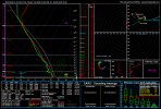
Where were these taken?Not quite the insane hodographs I was seeing yesterday (like the one that literally went off the chart due to the strength of the winds up to 1 KM), but that's more than ample shear.
Where were these taken?
Oops… sorry lolFlorida panhandle as indicated in my earlier post.
you can find the coordinates in the upper left of these soundingsWhere were these taken?
I have seen the coordinates before, but I don’t know how to tell where a location is based just on coordinates.you can find the coordinates in the upper left of these soundings
You can type them in at the Google Maps search bar and it'll take you to them.I have seen the coordinates before, but I don’t know how to tell where a location is based just on coordinates.
Ok awesome. Thank you.You can type them in at the Google Maps search bar and it'll take you to them.
As of this morning, SPC was being cautious about the northward extent of instability and moisture on Monday and Tuesday. Still think models aren't handling the moisture return very well, though sometimes early-season events like this get stuck on the coast. However, the system coming through this weekend looks to well up a lot of deep Gulf moisture ahead of the Mon-Tues system, which I'd have to reckon will give this system a boost.So as far as areas impacted by next Tuesday, do we think it'll be farther north than the Gulf Coast? Personally, I still believe it'll be further north than models currently have it.
.png")
.png")
.png")
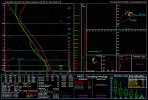
FWIW, CIPS-forecasted SHERB values via the GFS have been consistently robust over MS/AL/GA. While more classic parameters aren't showing very much over the area of interest, I still think the northward edge of the threat bears very close watching. A pretty minor difference in the amount of moisture and available energy could translate to a serious difference in the performance deeper inland, considering the wind fields at hand (sounding from East-Central AL).As of this morning, SPC was being cautious about the northward extent of instability and moisture on Monday and Tuesday. Still think models aren't handling the moisture return very well, though sometimes early-season events like this get stuck on the coast. However, the system coming through this weekend looks to well up a lot of deep Gulf moisture ahead of the Mon-Tues system, which I'd have to reckon will give this system a boost.


.png")

.png")